Nova Kakhovka
| Nova Kakhovka Нова Каховка | ||
|---|---|---|
 | ||
| ||
 | ||
 Nova Kakhovka | ||
| Coordinates: 46°46′N 33°22′E / 46.767°N 33.367°ECoordinates: 46°46′N 33°22′E / 46.767°N 33.367°E | ||
| Country Oblast Raion |
Ukraine Kherson Oblast Nova Kakhovka City Municipality | |
| Founded | 28 February 1952 | |
| Area | ||
| • Total | 222.7 km2 (86.0 sq mi) | |
| Elevation | 21 m (69 ft) | |
| Population (2005) | ||
| • Total | 72,700 | |
| • Density | 363/km2 (940/sq mi) | |
| Postal code | 74900 | |
| Area code(s) | +380 5549 | |
| Website | novakahovka.com.ua | |
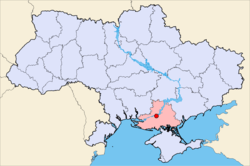
Nova Kakhovka (Ukrainian: Нова Каховка, Russian: Новая Каховка) is a city in the Kherson Oblast of southern Ukraine, recognized as the Monument of Architecture,[1] and was part of the Great Construction Projects of Communism.
It is designated as a separate raion (district) within the oblast, and is an important river port on Dnieper River and the Kakhovka Reservoir. It is also the site of the Tavria Games, (Ukrainian: Таврійські ігри, translit. Tavriys'ki ihry), the most popular annual international music festival in the region.
The current estimated population is around 52,611 (as of 2001), with an urban population of 75,392.

History
Nova Kakhovka was founded on 28 February 1952, in the place where, from 1891, the village Klyucheve had existed. It was in direct proximity of the established dam of the Kakhovka hydroelectric power plant (1947–1948), and was built to house the plant's construction workers. Since its founding, the city has been called Nova Kakhovka, or New Kakhova, to distinguish from the city of Kakhovka located 15 km (9.3 mi) away. After the construction of the power plant was finished, most of the workers stayed in Nova Kakhovka. The city of Nova Kakhovka is recognized as one of the most successful colonization sites of the Ukrainian South in recent years and earned a title of the Pearl of Lower Dnieper (Official website of the city).

Geography
The city is sometimes referred to as an oasis, because it was built on an area where sand was plentiful. During the construction of the city, the parks and sod were built and lain on the sandy ground. Also, the architectural plans were developed to build streets and squares in the way they would harmonize perfectly with the shoreline of the reservoir.
Modern Nova Kakhovka
Economy and transport
The economic activities in Nova Kakhovka are engineering (electrotechnology) and power production. Near the city the large North Crimean Canal begins, via which the southwest of the Kherson Oblast and the entire northern part of the Crimea are supplied with water coming from the Dnieper River.

The city is located between Kherson in the west and Melitopol in the east on the European route E58, which runs from Odessa to Rostov-on-Don near the city. The city contains a non-electrified, one lane railroad, an airport, a water route to the Black Sea, and a port which is located on the southwest part of the Khakovka Reservoir.
Administrative divisions
The Nova Kakhovka city has a small city and an urban type village within it, as well as eight small villages in the outlying area.
- Small towns and urban type villages: Tavriysk, Dnipryany
- Villages and rural type settlements: Korsunka, Maslivka, Novy Laheri, Obryvky, Pischane, Plodove, Raiske, Topolivka
Cities attractions
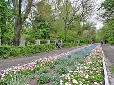
- Park of Stepan Faldzinsky, the Park Architecture Monument, is named after the native Polish of Podolie, the agrarian Stepan Faldzinsky who created the green oasis at the Oleshky Sands.
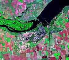
View of Nova Kakhovka
-

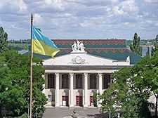
The administrative center of Nova Kakhovka
-

"The Central" Shopping Centre, former "Children's World"
-

Triumphal arch over Nova Kakhovka locks
-

The shoreline in Nova Kakhovka
-

The Park of Glory
Twin towns
- Saint-Étienne-du-Rouvray (France)
References
External links
| Wikimedia Commons has media related to Nova Kakhovka. |
- (Ukrainian) Оfficial city website
- (Ukrainian) Unofficial city website with newest photos
- (Russian) Unofficial city portal
- (Russian) City photos
- (Ukrainian) Tavria Games Festival
| |||||||||||||||||||||||
