Nový Knín
From Wikipedia, the free encyclopedia
| Nový Knín | |||
| Town | |||
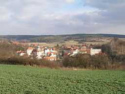
 Nový Knín from WNW | |||
|
|||
| Country | Czech Republic | ||
|---|---|---|---|
| Region | Central Bohemian | ||
| District | Příbram | ||
| Commune | Dobříš | ||
| River | Kocába | ||
| Elevation | 307 m (1,007 ft) | ||
| Coordinates | 49°47′N 14°17′E / 49.783°N 14.283°E | ||
| Area | 29.61 km2 (11.43 sq mi) | ||
| Population | 1,779 (2005-01-01) | ||
| Density | 60 / km2 (155 / sq mi) | ||
| Founded | 1331 | ||
| Mayor | Tomáš Havlíček | ||
| Timezone | CET (UTC+1) | ||
| - summer (DST) | CEST (UTC+2) | ||
| Postal code | 262 03 | ||
  Location in the Czech Republic
| |||
| Wikimedia Commons: Nový Knín | |||
| Statistics: statnisprava.cz | |||
| Website: www.mestonovyknin.cz | |||
Nový Knín is a town in the Central Bohemian region in the Czech Republic.
History
Until 1918, NOVÝ KNÍN - NEU KNIN was part of the Austrian monarchy (Austria side after the compromise of 1867), in the PRIBRAM - Příbram district, one of the 94 Bezirkshauptmannschaften in Bohemia.[1]

Austrian KK Journal 2 heller stamp, bilingual cancelled in 1908
A post-office was opened in 1868.
Twin municipality
References
- ↑ Die postalischen Abstempelungen auf den österreichischen Postwertzeichen-Ausgaben 1867, 1883 und 1890, Wilhelm KLEIN, 1967
External links
| Wikimedia Commons has media related to Nový Knín. |
This article is issued from Wikipedia. The text is available under the Creative Commons Attribution/Share Alike; additional terms may apply for the media files.

