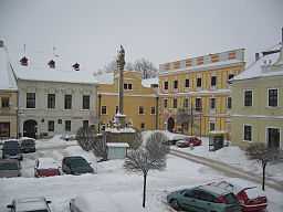
Nová Bystřice
| Nová Bystřice | |||
| Town | |||
 | |||
|
|||
| Country | Czech Republic | ||
|---|---|---|---|
| Region | South Bohemian | ||
| District | Jindřichův Hradec | ||
| Commune | Jindřichův Hradec | ||
| Municipality | Nová Bystřice | ||
| Elevation | 588 m (1,929 ft) | ||
| Coordinates | 49°1′9.33″N 15°6′11.37″E / 49.0192583°N 15.1031583°E | ||
| Area | 81.74 km2 (31.56 sq mi) | ||
| Population | 3,380 (2011) | ||
| Density | 41 / km2 (106 / sq mi) | ||
| First mentioned | 1175 | ||
| Mayor | Vladimir Blaha | ||
| Timezone | CET (UTC+1) | ||
| - summer (DST) | CEST (UTC+2) | ||
| Postal code | 378 33 | ||
  Location in the Czech Republic
| |||
| Wikimedia Commons: Nová Bystřice | |||
| Statistics: statnisprava.cz | |||
| Website: www.novabystrice.cz | |||
| Nová Bystřice (Nová Bystřice) | |
| Neubistritz | |
| Municipality with Commissioned Local Authority | |
| Country | Czech Republic |
|---|---|
| Region | South Bohemia |
| Little District | Jindřichův Hradec |
| Municipalities | Číměř, Nová Bystřice, Staré Město pod Landštejnem |
| Area | 196.64 km2 (75.92 sq mi) |
| Population | 4,612 (2009-12-31) |
| Density | 23 / km2 (60 / sq mi) |
Nová Bystřice (Czech pronunciation: [ˈnovaː ˈbɪstr̝̊ɪtsɛ]) is a town in the South Bohemian Region of the Czech Republic (WGS-84 coordinates N49°01'11", E15°06'02"). It has ca 3,400 inhabitants. The town lies on the border between Czech Republic and Austria (close to Austria's most northern point).
The villages and hamlets of Albeř, Artolec, Blato, Hradiště, Hůrky, Klášter, Klenová, Nový Vojířov, Ovčárna, Senotín, Skalka and Smrčná are administrative parts of Nová Bystřice.
History
The first written mention of Nová Bystřice was in 1175: the area was colonized by knights. Before that, there was a Slavic population (as evidenced by a Slavic burial ground). In 1276 it became the personal dominion of Jitka (Guty) von Habsburg, who was later the Czech Queen. In 1341 Bystřice was promoted to city status. During the reign of John the Blind it became a market town. Around the same time it suffered from great famine. The town was burned down by Jan Žižka in 1420. It was rebuilt and since then it has been called Nová ("New") Bystřice. In July 1533 a group of religious reformers killed 40 Catholic monks, along with other Catholics, and destroyed the monastery. About one-third of the population emigrated to America after 1870.
During the cold war, the Iron Curtain garrison was located in the town. The neighbouring village of Mnich was abandoned and destroyed due to its vicinity to the border.
Present
The nature park informally called Czech Canada is attractive and the number of inhabitants, as well as seasonal visitors, is growing. Major accommodation development projects are under way.
The presence of a border checkpoint is another important feature of the town, although heavy traffic is usually routed through other major checkpoints in Southern Bohemia.
Industry
Textile industry is the traditional business activity, however the recent years saw a drop in the demand. Alma Nová Bystřice and Otavan factory finished its operations.
A substantial number of residents work in the agricultural industry. People working in technical and administrative sector usually commute to Jindřichův Hradec. Increasing tourism is leading to the expansion of services (hotels, restaurants) in the town and is an important source of income, especially during summer months.
Tourist attractions
Nová Bystřice is the endpoint of a privately operated narrow gauge railroad to Jindřichův Hradec. During the tourist season, the trains are powered by historic steam engines and offer various entertainment.
The Monachus golf resort, situated on the town's southwestern edge, is a major attraction for golfers. It consists of 18-hole championship course and nine-hole public golf academy. The characteristic landscape of Czech Canada — hilly with many forests and meadows — is regarded as almost perfect for this game. The golf resort of Haugschlag (located in the neighbouring Austrian region of Waldviertel) is a few hundreds meters away, over the national border.
Nová Bystřice is a frequent destination of cyclists; many biking routes pass through the town, offering almost all degrees of difficulty.
External links
- Municipal website (Czech)/(German)
- Narrow-gauge railroad (Czech)/(English)
| Wikimedia Commons has media related to Nová Bystřice. |

