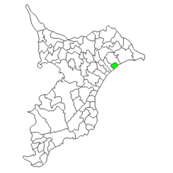
Nosaka, Chiba
From Wikipedia, the free encyclopedia
| Nozaka 野栄町 | |
|---|---|
| Former municipality | |
 | |
 Nozaka | |
| Coordinates: 35°39′50″N 140°34′36.90″E / 35.66389°N 140.5769167°ECoordinates: 35°39′50″N 140°34′36.90″E / 35.66389°N 140.5769167°E | |
| Country | Japan |
| Region | Kantō |
| Prefecture | Chiba Prefecture |
| District | Sōsa |
| Merged |
January 23, 2006 (now part of Sōsa) |
| Area | |
| • Total | 21.03 km2 (8.12 sq mi) |
| Population (September 30, 2005) | |
| • Total | 9,894 |
| • Density | 460/km2 (1,200/sq mi) |
| Time zone | Japan Standard Time (UTC+9) |
| Symbols | |
| - Tree | Pinus thunbergii |
| - Flower | Camellia sasanqua |
Nosaka (野栄町 Nosaka-machi) was a town located in Sōsa District Chiba Prefecture, Japan.
Noda and Sakae villages were established on April 1, 1889 within Sōsa District, Chiba. The two villages merged on July 17, 1954 to form Nosaka Town.
On January 23, 2006, Nozaka was merged with the neighboring city of Yōkaichiba to create the city of Sōsa.
This article is issued from Wikipedia. The text is available under the Creative Commons Attribution/Share Alike; additional terms may apply for the media files.