Normandy Dam
From Wikipedia, the free encyclopedia
| Normandy Dam | |
|---|---|
 Normandy Dam | |
| Coordinates | 35°27′56″N 86°14′33″W / 35.465476°N 86.24259°WCoordinates: 35°27′56″N 86°14′33″W / 35.465476°N 86.24259°W |
| Dam and spillways | |
| Impounds | Duck River |
| Length | 2,807 ft (856 m)[1] |
| Height | 110 ft (34 m)[2] |
| Reservoir | |
| Total capacity | 126,100 acre·ft (155,500 dam3)[2] |
| Catchment area | 195 sq mi (510 km2)[2] |
| Surface area | 2,490 acres (1,010 ha)[2] |
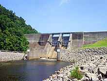
Normandy Dam is a dam built by the Tennessee Valley Authority (TVA) on the Duck River in the U.S. state of Tennessee. It straddles the border between Bedford and Coffee counties. Completed in 1976, the dam was built primarily for flood control and economic development purposes, and does not produce any electricity.
The dam is 110 feet (34 m) high and spans 2,807 feet (856 m) across the river valley.
References
- ↑ Normandy Reservoir, TVA.gov. Retrieved: 2 October 2013.
- ↑ 2.0 2.1 2.2 2.3 "Normandy Dam". National Performance of Dams Program, National Inventory of Dams. Stanford University. Retrieved 2013-02-02.
External links
| Wikimedia Commons has media related to Normandy Dam. |
- Normandy Reservoir — TVA site
| ||||||||||||||
This article is issued from Wikipedia. The text is available under the Creative Commons Attribution/Share Alike; additional terms may apply for the media files.