Norðausturkjördæmi
From Wikipedia, the free encyclopedia
| Norðausturkjördæmi Northeast | |
|---|---|
| Constituency of Iceland | |
 | |
| Country |
|
| Established | 1999 |
| Main town |
|
| Composition |
List
|
| Population (2009) | |
| • Total | 39,621 |
| • Electors | 28,362 |
| Representatives to Alþingi | 10 |
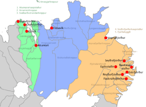
The Norðausturkjördæmi (i.e. Northeast) is one of the six constituencies (kjördæmi) of Iceland. Its major town is Akureyri.
Geography
It borders with the constituencies of Northwest and South. Its territory includes the glacier of Þrándarjökull and Tungnafellsjökull and, at its south-western borders, the northern part of the biggest one of Iceland: the Vatnajökull.
Administration
Composition
The constituency includes 22 municipalities, 5 counties and 2 regions.
- Municipalities: Akureyri, Borgarfjarðarhreppur, Breiðdalshreppur, Dalvík, Djúpivogur, Eyjafjarðarsveit, Fjallabyggð, Fjarðabyggð, Fljótsdalshérað, Fljótsdalshreppur, Grýtubakkahreppur, Hörgársveit, Langanesbyggð, Norðurþing, Seyðisfjörður, Skútustaðahreppur, Svalbarðshreppur, Svalbarðsstrandarhreppur, Þingeyjarsveit, Tjörneshreppur, Vopnafjörður
- Counties: Eyjafjarðarsýsla, Norður-Múlasýsla, Suður-Múlasýsla, Norður-Þingeyjarsýsla, Suður-Þingeyjarsýsla
- Regions: Austurland,[1] Norðurland eystra
Towns
The settlements with town status, listed per order of population, are 12:
- Akureyri (17,481)
- Húsavík (2,296)
- Reyðarfjörður (2,238)
- Egilsstaðir (2,200)
- Dalvík (1,800)
- Siglufjörður (1,438)
- Neskaupstaður (1,400)
- Eskifjörður (1,068)
- Ólafsfjörður (946)
- Seyðisfjörður (802)
- Vopnafjörður (682)
- Fáskrúðsfjörður (611)
Notes and references
- ↑ Partially included in the Constituency of South
External links
![]() Media related to Constituencies of Iceland at Wikimedia Commons
Media related to Constituencies of Iceland at Wikimedia Commons
Coordinates: 65°41′N 18°06′W / 65.683°N 18.100°W
This article is issued from Wikipedia. The text is available under the Creative Commons Attribution/Share Alike; additional terms may apply for the media files.