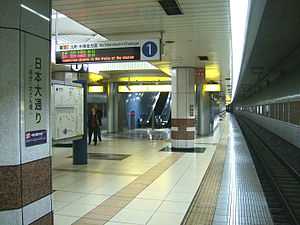
Nihon-ōdōri Station
Nihon-ōdōri Station 日本大通り駅 | |
 | |
|---|---|
| Platform level of Nihon-ōdōri Station | |
| Location | |
| Prefecture | Kanagawa (See other stations in Kanagawa) |
| City | Yokohama |
| Ward | Naka |
| Neighborhood etc. | Nihon-ōdōri 9 |
| Postal code | 231 - 0021 |
| (in Japanese) | 横浜市中区日本大通9 |
| History | |
| Year opened | 2004 |
| Rail services | |
| Operator(s) | Yokohama Minatomirai Railway Company |
| Line(s) | Minatomirai Line |
| Statistics | 20,314 passengers/day 2008 |
Nihon-ōdōri Station (日本大通り駅 Nihon-ōdōri-eki), is an underground metro station located in Naka-ku, Yokohama, Kanagawa Prefecture, Japan operated by the Yokohama Minatomirai Railway’s Minatomirai Line. It is 3.2 kilometers from the terminus of the Minatomirai Line at Yokohama Station. Its official name is Nihon-ōdōri (Kenchō-Ōsanbashi) Station (日本大通り(県庁・大さん橋)駅 Nihon-ōdōri (Kenchō-Ōsanbashi)-eki), including the sub-name in parentheses. Trains inter-run with the Tōkyū Tōyoko Line from Shibuya Station.
History
Nihon-ōdōri Station opened on February 1, 2004, with the opening of the Minatomirai Line.
Lines
- Yokohama Minatomirai Railway Company
Station layout
Nihon-ōdōri Station is an underground station with a single island platform serving two tracks.
Platforms
| 1 | ■Minatomirai Line | Motomachi-Chūkagai |
| 2 | ■Minatomirai Line | Bashamichi ・ Minatomirai・ Yokohama (■Tōkyū Tōyoko Line) to Shibuya |
Surrounding area
- Yokohama Stadium - 2-minute walk, heading south of the station
- Osanbashi Pier - 5-minute walk, heading north of the station
- Kanagawa Prefectural Government ("King's Tower") - at the Kenchō Exit (western end of the station)
- Naka Ward Office - 2-minute walk, heading south of the station
- Yokohama Archives of History
Adjacent stations
| « | Service | » | ||
|---|---|---|---|---|
| Minatomirai Line | ||||
| Bashamichi | Local | Motomachi-Chūkagai | ||
| Bashamichi | Express | Motomachi-Chūkagai | ||
| Bashamichi | Commuter Exp. | Motomachi-Chūkagai | ||
| Limited Exp.: no stop | ||||
References
- Harris, Ken and Clarke, Jackie. Jane's World Railways 2008-2009. Jane's Information Group (2008). ISBN 0-7106-2861-7
| Wikimedia Commons has media related to Nihon-ōdōri Station. |
External links
- Nihon-ōdōri Station (Minatomirai Line Official Website) (Japanese)
Coordinates: 35°26′48.46″N 139°38′33.53″E / 35.4467944°N 139.6426472°E
| |||||