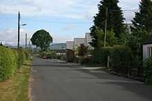
Newton Wamphray

Newton Wamphray is a village in Dumfries and Galloway. Wamphray is the name of the surrounding parish and of the Wamphray Water, which flows south-west through the Wamphray Glen to join the River Annan near the small village, or hamlet, of Newton.
The village is near the M74 motorway, near Annandale Water, roughly halfway between Moffat and Lockerbie, and has for centuries been close to the direct Glasgow to Carlisle route, which around 1776 was made into a turnpike road suitable for mail coaches travelling between England and Glasgow. Newton is on the main railway line south from Glasgow, and from about 1847 had its own station called Wamphray, but this closed in the 1960s.
Newton Wamphray primary school has been closed for several years, local children generally go to primary school in Lockerbie. The old school building now lies largely abandoned while the nature of its ownership is investigated. The old manse near the 1834 church has become a hotel; the historic church has been used for regular services over the past few years.
There are various historic and pre-historic sites near Newton Wamphray, including standing stones and the remains of a motte-and-bailey. A feud between local reiving families in the 16th century is remembered in the ballad, The Lads of Wamphray.
Before the 20th century the village was sometimes called Newton, or Newtoun, of Wamphray, and described as being in Annandale. Newton suggests "new village or farmstead", a placename derived from Old English niwe (new) + tun (farm). Scots toun meant a farm settlement before it came to mean a 'town'. The etymology of Wamphray is uncertain; some suggestions link 'Wam' to Gaelic Uamh (cave). Older spellings include Wamfry or Wamfray.
Sources
- Statistical Accounts of Scotland
- Great Britain Historical GIS Project: Wamphray
- Dictionary of Scots Language: toun
External links
| Wikimedia Commons has media related to Wamphray. |
See also
Coordinates: 55°14′24″N 3°23′46″W / 55.240°N 3.396°W