Newburn Bridge
| Newburn Bridge | |
|---|---|
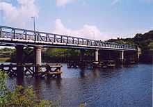
 Newburn Bridge viewed from the south east, June 2004 | |
| Carries |
Road Water mains Gas mains Telephone wires |
| Crosses | River Tyne |
| Locale | Tyne and Wear, England |
| Design | 4 span steel lattice-girder on three wrought iron, concrete-filled cylinders. |
| Total length | 144.8 m (475 ft) |
| Width | 8.54 m (28.0 ft) |
| Construction begin | 1892 |
| Construction end | 1893 |
| Opened | 1893 |
| Toll | Stopped 1947 |
| Daily traffic | Single road controlled by traffic lights. |
Newburn Bridge is a road bridge crossing the River Tyne at Newburn in Newcastle upon Tyne, England. It links Newburn, Walbottle and Throckley on the north side of the river with Ryton, Stella and Blaydon on the south side. The bridge is the western most crossing of the Tyne in the county of Tyne and Wear; the next crossing upstream, Wylam Bridge, is in Northumberland.
History
This part of the river has been forded since Roman times because it is the most eastern part of the Tyne that is easily fordable. There have also been numerous ferries operated in the part of the river around Newburn. A bridge was finally built between 1892 and 1893. It was designed by Sandeman & Moncrieff of Newcastle and built by Head Wrightson of Thornaby-on-Tees. It was opened on 21 May 1893. For the first 50 or so years of its use it was a toll bridge, until it was bought by Northumberland in 1947. The toll house on the north east side of the bridge has since been demolished. The bridge used to have two lanes crossing it up until the 1960s. It has since had single road traffic because of the weight limit of 9 tonnes (8.858 long tons; 9.921 short tons), later raised to 10 tonnes (9.842 long tons; 11.02 short tons).
In 2007 the bridge was closed for a number of months for renovation and repainting.
References
| Next crossing upstream | River Tyne | Next crossing downstream |
| Wylam Bridge | Newburn Bridge Grid reference: NZ162651 |
Blaydon Bridge (A1 road ) |
Coordinates: 54°58′48″N 1°44′42″W / 54.980°N 1.745°W