Neusiok Trail
| Neusiok Trail | |
|---|---|
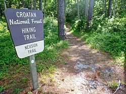
 A sign indicating the start of the trail near the Neuse River. | |
| Length | 20.4 miles (32.8 km)[1] |
| Location | North Carolina, United States |
| Designation |
Mountains-to-Sea Trail National Recreation Trail |
| Trailheads |
Pine Cliff Picnic Area Oyster Point Campground |
| Use | Hiking |
| Hiking details | |
| Trail difficulty | Easy[1] |
| Season | Year-round |
| Months | October — May (recommended) |
| Hazards |
American Alligator American Black Bear Biting flies Chiggers Diarrhea from water Limited water Mosquitos Poison ivy Severe weather Tick-borne diseases Venomous snakes Yellowjackets |
| Surface | natural, sand, boardwalk |
| Website | http://www.neusioktrail.org/ |
The Neusiok Trail /ˈnjuːsiɒk/ is a 20.4-mile (32.8 km)[1] hiking trail located in the Croatan National Forest in Carteret County, North Carolina.[2] The trail traverses the forest from a sandy beach on the Neuse River to a salt marsh on the Newport River, and along the way, it crosses cypress swamps, hardwood ridges, longleaf-pine savannah and pocosin—shrubby bogs[1] The entire Neusiok is part of the Mountains-to-Sea Trail (MST) which spans North Carolina,[3] and the MST in the Croatan is a designated National Recreation Trail.
History
The Neusiok Trail was created in 1971 by the Carteret County Wildlife Club. They battled briars, mud and mosquitoes for about five years to build the Neusiok Trail in cooperation with the U.S. Forest Service. The club continues to help with trail improvements.[1]
Hiking the trail
Hiking is best from October through May when the brush is thinnest and insects are sparse. The trail crosses several roads, so the trail can be shortened to suit a hiker's tastes. The trail crosses many wet areas, and despite a number of bridges and boardwalks, hikers may still need to wiktionary:wade through water.[1]
Navigation
The trail is marked by rectangular aluminum tags that are undamaged by regular prescribed burning.[1] The trail is also marked in places with Mountains-to-Sea Trail signs, as well as the MST's white, circle blazes.
Lodging and camping
Hikers may camp anywhere along the trail; however, three trail shelters offer a dry refuge:[1]
- Copperhead Landing is about halfway between the Pine Cliff Picnic Area and NC 306.
- Dogwood Camp is less than a mile south of NC 101.
- Blackjack Lodge is about one mile north of Mill Creek Road.
Each of the three-sided shelters has a fire grill and accommodates about three people. No drinking water is available along the trail; however, each shelter has a water pump. It is not recommended to rely upon the water pumps.
The Oyster Point Campground is the southern trail-head for the Neusiok, and it is situated on the banks of the Newport River. The year-round campground is nestled under tall loblolly pines, and it features 15 sites and two vault toilets. Each site has a picnic table, fire grill, parking spur, tent pad, and lantern post. Oyster Point also has a shallow water boat ramp which provides a launching point for boaters and anglers to access the Intracoastal Waterway.[4]
Camping is not permitted at the Pine Cliff Picnic Area, the Neusiok's northern trail-head.
Hazards

Hunters sometimes walk the Neusiok, so during hunting season, October through December, hikers are recommended to wear a bright orange hat or vest.[1] The trail passes through the habitats of the American Alligator and the American Black Bear. Poisonous snakes, copperheads, cottonmouths, timber (canebrake) and pygmy rattlesnakes, live in Croatan National Forest, so hikers are recommended to look before placing their hands or feet in thick brush.[1]
References
- ↑ 1.0 1.1 1.2 1.3 1.4 1.5 1.6 1.7 1.8 1.9
 This article incorporates public domain material from the United States Department of Agriculture document "Neusiok Trail: 20-mile walk of adventure" (retrieved on 2011-09-05).
- ↑ Manuel, John (2003). The natural traveler along North Carolina's coast. John F. Blair. pp. 203–204. ISBN 978-0-89587-272-2.
- ↑ Schlimmer, Erik (2005). Thru Hiker's Guide to America. McGraw-Hill Professional. p. 146. ISBN 978-0-07-143364-8.
- ↑
 This article incorporates public domain material from the United States Department of Agriculture document "Croatan National Forest: Land of Wonder" (retrieved on 2011-09-05).
External links
- Carteret County Wildlife Club website, whose members built and help maintain the trail.
- Unofficial website, with detailed information about the trail.
- Official Brochure
- Friends of the Mountains-to-Sea Trail website
Coordinates: 34°50′01″N 76°47′10″W / 34.83361°N 76.78611°W
| |||||||