Naturally built Coral Bridge
is an island in the
Andaman Islands of
India, located in
Ritchie's Archipelago. It is apparently named after
James George Smith Neill, a British soldier who had sternly dealt with the insurgents during the suppression of the 1857 Mutiny. It occupies an area of
18.9 square kilometres (7.3 sq mi). The island is located
40 kilometres (25 mi) north-east of
Port Blair, the capital of
Andaman and Nicobar Islands. It is the southernmost island of
Ritchie's Archipelago, save for uninhabited Sir Hugh Rose Island, which is another 3.8
km to the southeast of Neil Island. Administratively, the island is in the Neil Kendra panchayat, Port Blair sub-district of the
South Andaman district, in the Union Territory of the
Andaman and Nicobar Islands, India.

Coral Reef
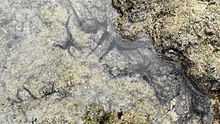
Star Fish at Neil Island
The population lives in five villages, which are numbered 1 through 5 (with population at 2001 census in parentheses):[1]
- Sitapur (267)
- Bharatpur (564)
- Neil Kendra (1064)
- Lakshmanpur (372)
- Ram Nagar (601)
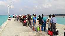
Bharathpur Jetty
There is a lone jetty at Bharathpur, which serves as the only entry–exit point of the island. The population of the island is 2868 as of the census of 2001. Agriculture is the primary occupation of the villagers, and the island supplies vegetables to the rest of
Andaman. Despite its minuscule tourist infrastructure, an increasing number of tourists have chosen to stay at Neil Island instead of neighbouring
Havelock Island. There are a handful of restaurants and basic beach hotels that cater to international and domestic tourists.
-
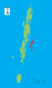
Ritchie's Archipelago within the Andaman Islands
-
Neil Island within Ritchie's Archipelago
Coordinates: 11°49′23″N 93°03′30″E / 11.82306°N 93.05833°E / 11.82306; 93.05833
References
http://www.andamanpearlpark.org/Aboutneilisland.aspx
http://www.andamanpearlpark.com/neil-island.php