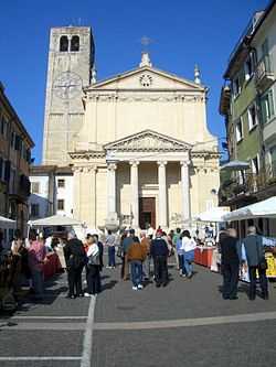
Negrar
From Wikipedia, the free encyclopedia
| Negrar | ||
|---|---|---|
| Comune | ||
| Comune di Negrar | ||
 | ||
| ||
 Negrar | ||
| Coordinates: 45°32′N 10°56′E / 45.533°N 10.933°ECoordinates: 45°32′N 10°56′E / 45.533°N 10.933°E | ||
| Country | Italy | |
| Region | Veneto | |
| Province | Verona (VR) | |
| Frazioni | Arbizzano, Jago, Fane, Mazzano, Montecchio, Prun, Santa Maria, Torbe | |
| Government | ||
| • Mayor | Giorgio Dal Negro | |
| Area | ||
| • Total | 40.5 km2 (15.6 sq mi) | |
| Elevation | 190 m (620 ft) | |
| Population (1 June 2007)[1] | ||
| • Total | 16,988 | |
| • Density | 420/km2 (1,100/sq mi) | |
| Demonym | Negraresi | |
| Time zone | CET (UTC+1) | |
| • Summer (DST) | CEST (UTC+2) | |
| Postal code | 37024 capoluogo, 37020 frazioni | |
| Dialing code | 045 | |
| Website | Official website | |
Negrar is a comune (municipality) in the Province of Verona in the Italian region Veneto, located about 110 km west of Venice and about 12 km northwest of Verona.
History
In prehistoric times, it was a center of the Arusnati, a not well-known population of perhaps mixed origins. In the Middle Ages it was a free commune until it was acquired by the Scaliger of Verona (14th century). Later it was part of the Republic of Venice, under which, in 1791, it received the right to hold a livestock market.
Economy
Negrar and its villages are mainly devoted to agricultural, with production of cherries, vine and fruit, and of wines such as Valpolicella and Recioto.
References
External links
This article is issued from Wikipedia. The text is available under the Creative Commons Attribution/Share Alike; additional terms may apply for the media files.
