Nea Erythraia
| Nea Erythraia Νέα Ερυθραία | |
|---|---|
| Location | |
 Nea Erythraia | |
| Coordinates | 38°5′N 23°49′E / 38.083°N 23.817°ECoordinates: 38°5′N 23°49′E / 38.083°N 23.817°E |
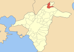
Location within Athens  | |
| Government | |
| Country: | Greece |
| Administrative region: | Attica |
| Regional unit: | North Athens |
| Municipality: | Kifisia |
| Population statistics (as of 2011)[1] | |
| Municipal unit | |
| - Population: | 17,379 |
| - Area: | 4.831 km2 (2 sq mi) |
| - Density: | 3,597 /km2 (9,317 /sq mi) |
| Other | |
| Time zone: | EET/EEST (UTC+2/3) |
| Elevation (center): | 310 m (1,017 ft) |
| Postal code: | 146 xx |
| Telephone: | 210 |
| Auto: | Z |
| Website | |
| www.dne.gov.gr | |
Nea Erythraia (Greek: Νέα Ερυθραία) is a suburb in the northeastern part of the Athens agglomeration, Greece. Since the 2011 local government reform it is part of the municipality Kifisia, of which it is a municipal unit.[2]
Geography
Nea Erythraia is situated at the western end of the forested Penteli mountain range. The small river Kifisos forms the northwestern border of the municipal unit. Nea Erythraia is situated 14 km northeast of Athens city centre. The built-up area of Nea Erythraia is continuous with that of the neighbouring suburb Kifisia. Motorway 1, Greek National Road 1 and Greek National Road 83 pass through the town.
For many years, Nea Erythraia was home to the senior division of Campion, one of Greece's oldest English-language schools.
On September 14, 2004, the paralympic flame arrived in Nea Erythraia as it travelled from Marathon.
Historical population
| Year | Population |
|---|---|
| 1981 | 10,100 |
| 1991 | 12,993 |
| 2001 | 15,439 |
| 2011 | 17,379 |
References
- ↑ Detailed census results 2011 (Greek)
- ↑ Kallikratis law Greece Ministry of Interior (Greek)
External links
- City of Nea Erythraia official website (Greek)
- http://emidius.mi.ingv.it/GNDT/T19990907/Athens990907_ismes/ate_html/09.html (Italian)
- Nea Erythraia Photos
 |
Acharnes | Kryoneri | Ekali |  |
| |
||||
| ||||
| | ||||
| Kifisia | Kifisia |
| |||||