| [3] |
Name on the Register[4] |
Image |
Date listed[5] |
Location |
City or town |
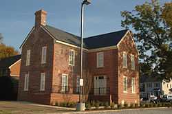
Summary |
|---|
| 1 |
Aberdeen Gardens |
|
01994-05-26May 26, 1994
(#94000456) |
Roughly bounded by Langston and Mary Peake Blvds., and Russell, Davis, Lewis, Weaver and Walker Rds.
37°02′00″N 76°24′21″W / 37.033333°N 76.405833°W / 37.033333; -76.405833 (Aberdeen Gardens) |
Hampton |
|
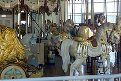
| 2 |
Buckroe Beach Carousel |
|
01992-10-27October 27, 1992
(#92001396) |
602 Settlers Landing Rd.
37°01′26″N 76°20′38″W / 37.023889°N 76.343889°W / 37.023889; -76.343889 (Buckroe Beach Carousel) |
Hampton |
|
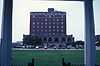
| 3 |
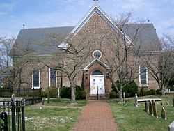
Chamberlin Hotel |
|
02007-03-21March 21, 2007
(#07000190) |
2 Fenwick Rd., Fort Monroe
37°00′03″N 76°18′48″W / 37.000833°N 76.313333°W / 37.000833; -76.313333 (Chamberlin Hotel) |
Hampton |
|
| 4 |
Chapel of the Centurion |
|
02011-03-28March 28, 2011
(#10000582) |
134 Bernard Rd., Fort Monroe
37°00′10″N 76°18′27″W / 37.002778°N 76.3075°W / 37.002778; -76.3075 (Chapel of the Centurion) |
Hampton |
Oldest continually used wooden military structure for religious services in the United States; built in 1858[6]
|
| 5 |
Chesterville Plantation Site |
|
01973-08-14August 14, 1973
(#73002211) |
Address Restricted (Near NASA Langley Research Center)
|
Hampton |
|
| 6 |
Reuben Clark House |
|
01984-08-16August 16, 1984
(#84003542) |
125 S. Willard Ave.
37°00′52″N 76°19′12″W / 37.014444°N 76.32°W / 37.014444; -76.32 (Reuben Clark House) |
Hampton |
|
| 7 |
Eight-Foot High Speed Tunnel |
|
01985-10-03October 3, 1985
(#85002798) |
Langley Research Center
37°04′56″N 76°20′29″W / 37.082222°N 76.341389°W / 37.082222; -76.341389 (Eight-Foot High Speed Tunnel) |
Hampton |
|
| 8 |
Fort Monroe |
|
01966-10-15October 15, 1966
(#66000912) |
Old Point Comfort
37°00′45″N 76°18′27″W / 37.0125°N 76.3075°W / 37.0125; -76.3075 (Fort Monroe) |
Hampton |
|
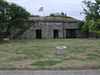
| 9 |
Fort Wool |
|
01969-11-25November 25, 1969
(#69000339) |
Island between Willoughby Spit and Old Point Comfort
36°59′12″N 76°18′04″W / 36.986667°N 76.301111°W / 36.986667; -76.301111 (Fort Wool) |
Hampton |
|
| 10 |
Full Scale Tunnel |
|
01985-10-03October 3, 1985
(#85002795) |
Langley Research Center
37°04′58″N 76°20′30″W / 37.082778°N 76.341667°W / 37.082778; -76.341667 (Full Scale Tunnel) |
Hampton |
|
| 11 |
Hampton City Hall |
|
02007-08-08August 8, 2007
(#07000806) |
100 Kings Way
37°01′34″N 76°20′40″W / 37.026111°N 76.344444°W / 37.026111; -76.344444 (Hampton City Hall) |
Hampton |
|
| 12 |
Hampton Downtown Historic District |
|
02010-12-27December 27, 2010
(#10001062) |
Roughly bounded by Franklin St., Lincoln St., Settlers Landing Rd., Eaton St.
37°01′34″N 76°20′40″W / 37.026111°N 76.344444°W / 37.026111; -76.344444 (Hampton Downtown Historic District) |
Hampton |
|
| 13 |
Hampton Institute |
|
01969-11-12November 12, 1969
(#69000323) |
Northwest of the junction of US 60 and the Hampton Roads Bridge Tunnel
37°01′13″N 76°20′09″W / 37.020278°N 76.335833°W / 37.020278; -76.335833 (Hampton Institute) |
Hampton |
|
| 14 |
Hampton National Cemetery |
|
01996-02-26February 26, 1996
(#96000038) |
Junction of Cemetery Rd. and Marshall Ave.
37°01′11″N 76°19′48″W / 37.019722°N 76.33°W / 37.019722; -76.33 (Hampton National Cemetery) |
Hampton |
|
| 15 |
Herbert House |
|
01972-02-23February 23, 1972
(#72001504) |
East end of Marina Rd. on Hampton Creek
37°00′58″N 76°20′37″W / 37.016111°N 76.343611°W / 37.016111; -76.343611 (Herbert House) |
Hampton |
|
| 16 |
Little England Chapel |
|
01982-07-08July 8, 1982
(#82004564) |
4100 Kecoughtan Rd.
37°00′47″N 76°21′11″W / 37.013056°N 76.353056°W / 37.013056; -76.353056 (Little England Chapel) |
Hampton |
|
| 17 |
Lunar Landing Research Facility |
|
01985-10-03October 3, 1985
(#85002808) |
Langley Research Center
37°06′08″N 76°23′23″W / 37.102222°N 76.389722°W / 37.102222; -76.389722 (Lunar Landing Research Facility) |
Hampton |
|
| 18 |
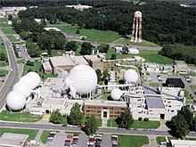
NASA Langley Research Center (LaRC) Historic District |
|
02012-06-27June 27, 2012
(#12000374) |
Roughly bounded by Wythe Creek Rd., Commander Shepard Blvd., Brick Kiln Cr., & Langley Air Force Base
37°05′34″N 76°22′53″W / 37.09277°N 76.38133°W / 37.09277; -76.38133 (NASA Langley Research Center (LaRC) Historic District) |
Hampton |
|
| 19 |
Old Wythe Historic District |
|
02012-10-31October 31, 2012
(#12000905) |
Roughly bounded by Hanover St., Pear Ave., Hampton Ave, & Kecoughtan Rd.
37°00′13″N 76°22′40″W / 37.003512°N 76.377826°W / 37.003512; -76.377826 (Old Wythe Historic District) |
Hampton |
|
| 20 |
Pasture Point Historic District |
|
02012-10-22October 22, 2012
(#08000940) |
Bounded by Hampton River on the east, Bright's Creek on the north, Wine St. on the west, and Syms St. on the south
37°01′56″N 76°20′26″W / 37.032158°N 76.340647°W / 37.032158; -76.340647 (Pasture Point Historic District) |
Hampton |
|
| 21 |
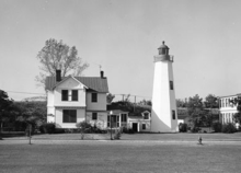
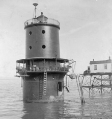
Old Point Comfort Lighthouse |
|
01973-03-01March 1, 1973
(#73002212) |
Fenwick Rd., southwest of the east gate of Fort Monroe
37°00′06″N 76°18′25″W / 37.001667°N 76.306944°W / 37.001667; -76.306944 (Old Point Comfort Lighthouse) |
Hampton |
|
| 22 |
Phoebus Historic District |
|
02006-12-01December 1, 2006
(#06001098) |
Roughly bounded by I-64, Mallory St., E. County St. and Willard Ave.
37°01′07″N 76°19′14″W / 37.018611°N 76.320556°W / 37.018611; -76.320556 (Phoebus Historic District) |
Hampton |
|
| 23 |
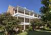
Quarters 1 |
|
02011-03-28March 28, 2011
(#10000583) |
151 Bernard Rd., Fort Monroe
37°00′14″N 76°18′20″W / 37.003889°N 76.305556°W / 37.003889; -76.305556 (Quarters 1) |
Hampton |
Headquarters of Fort Monroe from 1819 to 1907;[7] quarters used by Abraham Lincoln while planning the attack on Norfolk during the American Civil War[8]
|
| 24 |
Quarters 17 |
|
02011-03-28March 28, 2011
(#10000584) |
41A, 41B, 47A, 47B Bernard Rd., Fort Monroe
37°00′09″N 76°18′32″W / 37.0025°N 76.308889°W / 37.0025; -76.308889 (Quarters 17) |
Hampton |
Quarters of Robert E. Lee during the construction of Fort Monroe, 1831–1834;[9]
|
| 25 |
Rendezvous Docking Simulator |
|
01985-10-03October 3, 1985
(#85002809) |
Langley Research Center
37°05′08″N 76°22′41″W / 37.085556°N 76.378056°W / 37.085556; -76.378056 (Rendezvous Docking Simulator) |
Hampton |
|
| 26 |
Scott House |
|
01999-08-05August 5, 1999
(#99000967) |
232 S. Armistead Ave.
37°01′22″N 76°21′02″W / 37.022778°N 76.350556°W / 37.022778; -76.350556 (Scott House) |
Hampton |
|
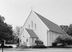
| 27 |
St. John's Church |
|
01970-02-26February 26, 1970
(#70000871) |
Northwest corner of W. Queen and Court Sts.
37°01′33″N 76°20′49″W / 37.025833°N 76.346944°W / 37.025833; -76.346944 (St. John's Church) |
Hampton |
The oldest English-speaking church in the US, est. 1610.[10]
|
| 28 |
Thimble Shoal Light Station |
|
02002-12-02December 2, 2002
(#02001436) |
Approximately 1.5 mi (2.4 km). east of Fort Monroe Military Reservation
37°01′02″N 76°14′24″W / 37.017222°N 76.24°W / 37.017222; -76.24 (Thimble Shoal Light Station) |
Hampton |
|
| 29 |
William H. Trusty House |
|
01979-06-22June 22, 1979
(#79003280) |
76 W. County St.
37°01′18″N 76°19′29″W / 37.021667°N 76.324722°W / 37.021667; -76.324722 (William H. Trusty House) |
Hampton |
|
| 30 |
Variable Density Tunnel |
|
01985-10-03October 3, 1985
(#85002795) |
Langley Research Center
37°04′43″N 76°20′39″W / 37.078611°N 76.344167°W / 37.078611; -76.344167 (Variable Density Tunnel) |
Hampton |
|
| 31 |
Victoria Boulevard Historic District |
|
01984-10-04October 4, 1984
(#84000039) |
Roughly bounded by Sunset Creek, Armisted and Linden Aves., and Bridge St.
37°01′09″N 76°20′53″W / 37.019167°N 76.348056°W / 37.019167; -76.348056 (Victoria Boulevard Historic District) |
Hampton |
|

.jpg)

.jpg)

.jpg)