| [3] |
Name on the Register[4] |
Image |
Date listed[5] |
Location |
City or town |
Summary |
|---|
| 1 |
Auburn |
|
02008-02-21February 21, 2008
(#08000068) |
17736 Auburn Rd.
38°30′18″N 77°55′39″W / 38.504942°N 77.927583°W / 38.504942; -77.927583 (Auburn) |
Brandy Station |
|
| 2 |
Burgandine House |
|
01997-03-07March 7, 1997
(#97000153) |
807 S. Main St.
38°28′06″N 77°59′49″W / 38.468333°N 77.996944°W / 38.468333; -77.996944 (Burgandine House) |
Culpeper |
|
| 3 |
Clifton |
|
02008-09-17September 17, 2008
(#08000911) |
7091 Monumental Mills Rd.
38°36′29″N 77°00′20″W / 38.607922°N 77.005644°W / 38.607922; -77.005644 (Clifton) |
Rixeyville vicinity |
|
| 4 |
Croftburn Farm |
|
02001-02-16February 16, 2001
(#01000153) |
18175 Croftburn Farm Rd.
38°27′29″N 77°57′32″W / 38.458056°N 77.958889°W / 38.458056; -77.958889 (Croftburn Farm) |
Culpeper |
|
| 5 |
Culpeper Historic District |
|
01987-10-22October 22, 1987
(#87001809) |
Roughly bounded by Edmonson St., Southern RR, Stevens, & West Sts.
38°28′22″N 77°59′44″W / 38.472778°N 77.995556°W / 38.472778; -77.995556 (Culpeper Historic District) |
Culpeper |
|
| 6 |
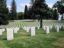
Culpeper National Cemetery |
|
01996-02-26February 26, 1996
(#96000029) |
305 U.S. Ave.
38°28′11″N 77°59′30″W / 38.469722°N 77.991667°W / 38.469722; -77.991667 (Culpeper National Cemetery) |
Culpeper |
|
| 7 |
Eckington School |
|
02001-02-16February 16, 2001
(#01000154) |
Jct. of VA 658 and VA 661
38°24′13″N 77°55′27″W / 38.403611°N 77.924167°W / 38.403611; -77.924167 (Eckington School) |
Culpeper |
|
| 8 |
Elmwood |
|
01986-01-16January 16, 1986
(#86000075) |
US 522 W
38°32′44″N 78°07′02″W / 38.545556°N 78.117222°W / 38.545556; -78.117222 (Elmwood) |
Boston |
A boundary increase on 2013-12-24 under the name "Elmwood Farm and Browning Store" included an additional 5 acres (2.0 ha)
|
| 9 |
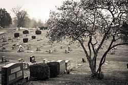
Fairview Cemetery |
|
02006-01-11January 11, 2006
(#05001521) |
VA 522, approx. 1/2 mi. W of Main St.
38°28′52″N 78°00′19″W / 38.481111°N 78.005278°W / 38.481111; -78.005278 (Fairview Cemetery) |
Culpeper |
|
| 10 |
Farley |
|
01976-05-06May 6, 1976
(#76002100) |
N of Brandy Station on VA 679, S of Hazel River
38°32′29″N 77°53′42″W / 38.541389°N 77.895°W / 38.541389; -77.895 (Farley) |
Brandy Station |
|
| 11 |
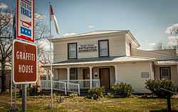
Graffiti House |
|
02005-11-17November 17, 2005
(#05001274) |
19484 Rd.
38°30′15″N 77°53′27″W / 38.504167°N 77.890833°W / 38.504167; -77.890833 (Graffiti House) |
Brandy Station |
Graffiti House, a field hospital during the Civil War. Many signatures and hand drawings by soldiers have been discovered on the inside walls.
|
| 12 |
Greenville |
|
01980-03-17March 17, 1980
(#80004184) |
NE of Raccoon's Ford
38°22′24″N 77°55′11″W / 38.373333°N 77.919722°W / 38.373333; -77.919722 (Greenville) |
Raccoon's Ford |
|
| 13 |
Greenwood |
|
01985-11-22November 22, 1985
(#85002914) |
1931 Orange Rd.
38°27′08″N 77°59′51″W / 38.452222°N 77.9975°W / 38.452222; -77.9975 (Greenwood) |
Culpeper |
|
| 14 |
Hill Mansion |
|
01980-03-17March 17, 1980
(#80004182) |
501 East St.
38°28′13″N 77°59′43″W / 38.470278°N 77.995278°W / 38.470278; -77.995278 (Hill Mansion) |
Culpeper |
|
| 15 |
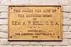
A. P. Hill Boyhood Home |
|
01973-10-02October 2, 1973
(#73002006) |
102 N. Main St.
38°28′24″N 77°59′47″W / 38.473333°N 77.996389°W / 38.473333; -77.996389 (A. P. Hill Boyhood Home) |
Culpeper |
|
| 16 |
Little Fork Church |
|
01969-11-12November 12, 1969
(#69000234) |
Jct. of Rtes. 624 and 726
38°35′59″N 77°57′18″W / 38.599722°N 77.955°W / 38.599722; -77.955 (Little Fork Church) |
Rixeyville |
|
| 17 |
Locust Grove |
|
01985-10-10October 10, 1985
(#85003131) |
Locust Grove Farm, Virginia 736
38°18′59″N 78°02′46″W / 38.316389°N 78.046111°W / 38.316389; -78.046111 (Locust Grove) |
Rapidan |
National Register of Historic Places plaque at driveway to Locust Grove, Rapidan, VA
|
| 18 |
Madden's Tavern |
|
01984-08-16August 16, 1984
(#84003526) |
VA 610
38°25′57″N 77°49′16″W / 38.4325°N 77.821111°W / 38.4325; -77.821111 (Madden's Tavern) |
Lignum |
|
| 19 |
Maple Springs |
|
01997-12-12December 12, 1997
(#97001510) |
20509 Clover Hill Rd.
38°34′56″N 77°53′28″W / 38.582222°N 77.891111°W / 38.582222; -77.891111 (Maple Springs) |
Jeffersonton |
|
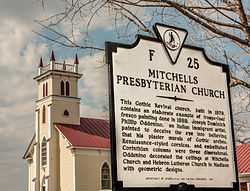
| 20 |
Mitchells Presbyterian Church |
|
01980-05-07May 7, 1980
(#80004183) |
VA 652
38°22′46″N 78°01′27″W / 38.379444°N 78.024167°W / 38.379444; -78.024167 (Mitchells Presbyterian Church) |
Mitchells |
|
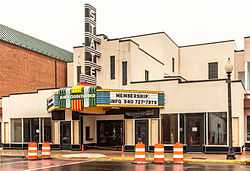
| 21 |
Pitts Theatre |
|
02008-05-15May 15, 2008
(#08000420) |
303-307 S. Main St.
38°28′18″N 77°59′48″W / 38.471756°N 77.996542°W / 38.471756; -77.996542 (Pitts Theatre) |
Culpeper |
|
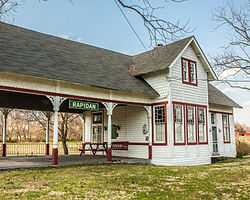
| 22 |
Rapidan Historic District |
|
01987-05-08May 8, 1987
(#87000723) |
Jct. of VA 614, Virginia 615, and VA 673
38°18′35″N 78°04′08″W / 38.309722°N 78.068889°W / 38.309722; -78.068889 (Rapidan Historic District) |
Rapidan |
Includes such structures as the Rapidan Passenger Depot.
|
| 23 |
Salubria |
|
01970-02-16February 16, 1970
(#70000789) |
E of jct. of Rtes. 3 and 663
38°26′21″N 77°53′07″W / 38.439167°N 77.885278°W / 38.439167; -77.885278 (Salubria) |
Stevensburg |
|
| 24 |
Signal Hill |
|
01999-01-21January 21, 1999
(#98001650) |
16190 Germanna Hwy.
38°26′55″N 77°57′15″W / 38.448611°N 77.954167°W / 38.448611; -77.954167 (Signal Hill) |
Culpeper |
|
| 25 |
Slaughter-Hill House |
|
01989-03-16March 16, 1989
(#89000203) |
306 N. West St.
38°28′29″N 77°59′52″W / 38.474722°N 77.997778°W / 38.474722; -77.997778 (Slaughter-Hill House) |
Culpeper |
|
| 26 |
South East Street Historic District |
|
02009-08-27August 27, 2009
(#09000663) |
S. East, E. Asher, E. Chandler, and Page Sts., and Culpeper National Cemetery
38°28′09″N 77°59′46″W / 38.469044°N 77.996008°W / 38.469044; -77.996008 (South East Street Historic District) |
Culpeper |
|

.jpg)