Natien
From Wikipedia, the free encyclopedia
| Natien | |
|---|---|
| Commune and village | |
 Natien | |
| Coordinates: 11°19′55″N 5°49′35″W / 11.33194°N 5.82639°WCoordinates: 11°19′55″N 5°49′35″W / 11.33194°N 5.82639°W | |
| Country |
|
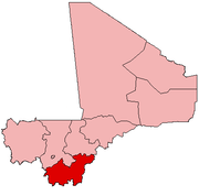
| Region | Sikasso Region |
| Cercle | Sikasso Cercle |
| Area[1] | |
| • Total | 207 km2 (80 sq mi) |
| Population (2009 census)[2] | |
| • Total | 7,404 |
| • Density | 36/km2 (93/sq mi) |
| Time zone | GMT (UTC+0) |
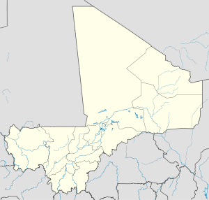
Natien is a village and rural commune in the Cercle of Sikasso in the Sikasso Region of southern Mali. The commune covers an area of 207 square kilometers and includes 9 villages.[3] In the 2009 census it had a population of 7,404.[2] The village of Natien, the administrative center (chef-lieu) of the commune, is 18 km west of Sikasso on the RN7, the main road linking Sikasso and Bougouni.
References
- ↑ "Common and Fundamental Operational Datasets Registry: Mali", United Nations Office for the Coordination of Humanitarian Affairs. commune_mali.zip (Originally from the Direction Nationale des Collectivités Territoriales, République du Mali)
- ↑ 2.0 2.1 Resultats Provisoires RGPH 2009 (Région de Sikasso) (in French), République de Mali: Institut National de la Statistique.
- ↑ Communes de la Région de Sikasso (in French), Ministère de l’administration territoriale et des collectivités locales, République du Mali.
External links
- Plan de Sécurité Alimentaire Commune Rurale de Natien 2006-2010 (in French), Commissariat à la Sécurité Alimentaire, République du Mali, USAID-Mali, 2006.
This article is issued from Wikipedia. The text is available under the Creative Commons Attribution/Share Alike; additional terms may apply for the media files.