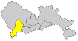
Nanshan District, Shenzhen
| Nanshan 南山 | |
|---|---|
| District | |
南山区 | |
 | |
 | |
| Country | China |
| Province | Guangdong |
| Prefecture | Shenzhen |
| Area | |
| • Total | 151 km2 (58 sq mi) |
| Population | |
| • Total | 2,200,000 |
| • Density | 15,000/km2 (38,000/sq mi) |
| Time zone | China Standard (UTC+8) |
| Area code(s) | 0755 |
| Website | http://www.szns.gov.cn/ |
Nanshan District (simplified Chinese: 南山区; traditional Chinese: 南山區; pinyin: Nánshān Qū) is one of the seven districts comprising Shenzhen. It encompasses the southwest area of the Shenzhen Special Economic Zone, with a population of 1.08 million. The size of the district is 182 km². The district of Nanshan is located to the west of Shenzhen Bay, east of the Pearl River entrance, south of Yangtaishan, north of Inner Lingding Island and Dachan Island, and across the sea of Hong Kong's Yuenlong. In year 2012, the district of Nanshan's local GDP output exceeded 280 billion RMB. The region is developed in the tourist industry and is home to famous sight-seeing locations including Window of the World.
Administrative Division
Nanshan District is organized into the following sub-districts.
Transportation

Shenzhen Metro
Shenzhen Metro began its construction in 1999, and officially opened to the public in December 28, 2004. As of June 2011, Shenzhen Metro's second phase operations has been completed, with a total of 5 lines and 178 km long. The 5 lines include Luobao Line (originally Line 1), Shekou Line (originally Line 2), Longgang Line (originally Line 3), Longhua Line (originally Line 4), and Huanzhong Line (originally Line 5). The Shenzhen Metro is continuing its development of the subway system, and plans to have 5 more lines completed by the end of 2015, which includes the Airport Express Line, that connects to the new Shenzhen Airport. The Shenzhen metro also plans to have 10 more lines completed after the year 2020. The Shenzhen Metro can be described as one of the fastest developing subway/train systems in the world, bringing convenience to not only the residents of the city but also to tourists wishing to visit the city. The Luobao Line and Shekou Line covers the majority of area in the district of Nanshan.
Pingnan railway
- Shekou West 蛇口西站
- Mawan 妈湾站
- Shenzhen West 深圳西站 (the only passenger station available on this line)
- Xili 西丽站
Ports
- Shekou
- Dong Jiaotou
- Chiwan
- Mawan
Access to Hong Kong
The Shenzhen Ferry Terminal in Shekou offers service to Hong Kong (Hong Kong Island, Kowloon, and Hong Kong International Airport), Zhuhai and Macau.[1] The ferry takes approximately 45 minutes to reach Hong Kong. Cross boundary coaches to and from Hong Kong are also available at the Shenzhen Bay Control Point[2] (along the Hong Kong-Shenzhen Western Corridor).
Economy

Tencent Limited has its headquarters in the Hi-tech Park (新科技园 Xīn Kējì Yuán) in Nanshan,[3] as does ZTE.[4]
China Nepstar has its headquarters on the 6th floor of Block B of the Xinnengyuan Building (S: 新能源大厦, T: 新能源大廈, P: Xīnnéngyuán Dàshà) in Nanshan District.[5]
Schools
Universities
Eight of Shenzhen's eleven full-time universities are located in Nanshan:[6]
- Shenzhen University
- Shenzhen Polytechnic
- Shenzhen University City
- Tsinghua University [7]
- Peking University
- Harbin Institute of Technology
- Financial College of Nankai University
- Shenzhen Virtual University Park [8]
Primary schools
- Nanshan Foreign Languages School 南山外国语学校 The most prestigious elementary school in Nanshan District
- Yueliangwan Primary School 月亮湾小学
- Nanshan Primary School 南山小学
- Nanyuan Primary School 南园小学
- Xiangnan Primary School 向南小学
- Nanshan Experimental Primary School 南山实验小学
- Qianhai Primary School 前海小学
Middle schools
- "Middle School" may refer to either 7-9 and/or 10-12 schools
- Shenzhen Nanshan Foreign Languages school 深圳南山外国语学校 - The most profound middle school in the Nanshan District, having the highest English exam score in the Nanshan district every year for the country's yearly High School Entrance Exam. Alumni includes graduates currently in Peking University, TsingHua University, Schulich School of Business (York University), Brandeis University, Stanford University, Northeastern University, University of Bath etc.
- Shenzhen Yucai School 深圳育才学校 The largest school in Nanshan District.
- Shenzhen Experimental School 深圳实验学校高中部
- Lixiang Middle School 荔香中学
- Nantou Middle School 南头中学
- OCT Middle School 华侨城中学
- Shekou Middle School 蛇口中学
- Shenzhen Nanshan Bilingual School, Cambridge International Centre, (CIC), Middle School,
International High Schools and Private High Schools
There are four international high schools and private high schools in NanShan:
- The International School of Nanshan Shenzhen,
- ShenZhen NanShan Bilingual School, Cambridge International Centre, (CIC), A - Level,
- Shekou International School and
- QSI.
These high schools all offer British, University of Cambridge International Centre (CIC) A - Level or North American style curricula, with English as the language of instruction.
Tourist attractions
- Guandi Temple 关帝庙
- Xin'an Old Town 新安古城
- Window of the World 世界之窗
- Happy Valley 欢乐谷
Overseas Chinese Town (OCT) 华侨城 OCT East东部华侨城 The mixC 万象城 Coastal City 海岸城 OCT Bay 欢乐海岸 Shenzhen Bay 深圳湾 Shenzhen Bay Sports Centre (Spring Cocoon) 深圳湾体育馆
References
- ↑ http://www.xunlongferry.com/e-shouye.asp][http://www.shenzhenparty.com/content/hongkong_shekou_zhuhai_ferry_schedule
- ↑ http://www.td.gov.hk/transport_in_hong_kong/access_to_shenzhen_bay_port/index.htm#2.1
- ↑ "Contact Us." Tencent. Retrieved on September 28, 2011. "Tencent Building, Kejizhongyi Avenue, Hi-techPark,Nanshan District,Shenzhen." Address in Chinese: "深圳市南山区高新科技园中区一路腾讯大厦"
- ↑ "Contact Us." ZTE. Retrieved on November 19, 2012. "No. 55, Hi-tech Road South, ShenZhen, P.R.China" - Chinese address: "深圳市科技南路55号"
- ↑ "Contact Us." China Nepstar. Retrieved on November 19, 2012. "China Nepstar Chain Drugstore Ltd. Floor 6, Block B, Xinnengyuan Building, Nanhai Road, Nanshan District, Shenzhen, CHINA (518054)" - Map - Address in Chinese: "地址:深圳市南山区南海大道新能源大厦 B 座 6 楼 (518054)" - Chinese Map
- ↑ http://www.szns.gov.cn/main_en/generalinfo/
- ↑ http://www.tsinghua-sz.cn/
- ↑ http://www.szvup.com/Html/englishh/83264822729835.html
External links
| Wikimedia Commons has media related to Nanshan District, Shenzhen. |
Coordinates: 22°30′05.83″N 113°54′28.16″E / 22.5016194°N 113.9078222°E
| |||||||||||||||||||
| ||||||||||||||||||||||||||||||||
| |||||||||||||||||||||||||||||||||||||||||||||||||||||||||||||||||||||||||||