Nöbdenitz
From Wikipedia, the free encyclopedia
| Nöbdenitz | |
|---|---|
 | |
 Nöbdenitz | |
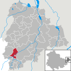
Location of Nöbdenitz within Altenburger Land district  | |
| Coordinates: 50°52′38″N 12°17′6″E / 50.87722°N 12.28500°ECoordinates: 50°52′38″N 12°17′6″E / 50.87722°N 12.28500°E | |
| Country | Germany |
| State | Thuringia |
| District | Altenburger Land |
| Municipal assoc. | Oberes Sprottental |
| Subdivisions | 5 |
| Government | |
| • Mayor | Günter Heydenreich |
| Area | |
| • Total | 10.01 km2 (3.86 sq mi) |
| Elevation | 229 m (751 ft) |
| Population (2012-12-31)[1] | |
| • Total | 909 |
| • Density | 91/km2 (240/sq mi) |
| Time zone | CET/CEST (UTC+1/+2) |
| Postal codes | 04626 |
| Dialling codes | 034496 |
| Vehicle registration | ABG |
| Website | www.noebdenitz.de |
Nöbdenitz is a German municipality in the Thuringian district of Altenburger Land.

1000-year-old oak
Geography
Neighboring municipalities
Municipalities near Nöbdenitz are Drogen, Löbichau, Posterstein, the City of Schmölln, Vollmershain, and Wildenbörten.
Municipal arrangement
The municipality of Nöbdenitz consists of 5 subdivisions: Nöbdenitz, Burkersdorf (in Schmölln), Lohma, Untschen, and Zagkwitz.
Business and transportation
Nöbdenitz has a train station on the line that goes from Gera to Gößnitz as well as to Altenburg.
References
- ↑ "Bevölkerung der Gemeinden, erfüllenden Gemeinden und Verwaltungsgemeinschaften nach Geschlecht in Thüringen". Thüringer Landesamt für Statistik (in German). 13 July 2013.
- This article incorporates information from the German Wikipedia.
This article is issued from Wikipedia. The text is available under the Creative Commons Attribution/Share Alike; additional terms may apply for the media files.