Myjava District
From Wikipedia, the free encyclopedia
| Myjava District | |
|---|---|
| District | |
 | |
| Country | Slovakia |
| Region (kraj) | Trenčín Region |
| Area | |
| • Total | 326 km2 (126 sq mi) |
| Population (2001) | |
| • Total | 29,243 |
| • Density | 90/km2 (230/sq mi) |
| Time zone | CET (UTC+1) |
| • Summer (DST) | CEST (UTC+2) |
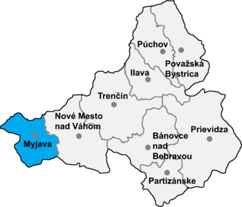
Myjava District (Slovak: okres Myjava, Hungarian: Milavai járás) is a district in the Trenčín Region of western Slovakia.[1] It is located in the area of the Myjava Hills. Myjava district belongs to the smaller districts in Slovakia and the population density is slightly under the country average. In the north it borders with the Czech Republic. Myjava district was established in 1923 and in its present borders exists from 1996.[2]
Municipalities
- Brestovec
- Brezová pod Bradlom
- Bukovec
- Hrašné
- Chvojnica
- Jablonka
- Kostolné
- Košariská
- Krajné
- Myjava
- Podkylava
- Polianka
- Poriadie
- Priepasné
- Rudník
- Stará Myjava
- Vrbovce
References
External links
| |||||||
Coordinates: 48°45′2″N 17°33′55″E / 48.75056°N 17.56528°E
This article is issued from Wikipedia. The text is available under the Creative Commons Attribution/Share Alike; additional terms may apply for the media files.