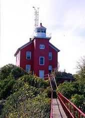
Muskegon Breakwater Light
From Wikipedia, the free encyclopedia
 | |
| Muskegon Breakwater Lighthouse | |
| Location | Muskegon, Michigan |
|---|---|
| Coordinates | 43°13′27″N 86°20′50″W / 43.2241°N 86.3471°WCoordinates: 43°13′27″N 86°20′50″W / 43.2241°N 86.3471°W |
| Year first constructed | 1851 |
| Year first lit | 1871 |
| Foundation | square steel equipment room |
| Construction | steel |
| Tower shape | square pyramidal |
| Markings / pattern | red |
| Height | 53 feet (16 m) |
| Focal height | 70 feet (21 m) |
| Range | 8 nautical miles (15 km; 9.2 mi) |
| Characteristic | red light, 3s on, 3s off |
| Fog signal | Horn: 2 blasts ev 20s |
| ARLHS number | USA-518 |
| USCG number | 7-18705 |
The Muskegon Breakwater lighthouse is located on the end of the south arm of the Muskegon breakwater surrounding the mouth of the Muskegon channel in Muskegon, Michigan.
The site is accessible by walking the breakwater, but the lighthouse is closed to the public.
In 2008 the lighthouse became available for transfer under NHLPA, and in June 2010 ownership was transferred to the Michigan Lighthouse Conservancy.
See also
References
- "Historic Light Station Information and Photography: Michigan". United States Coast Guard Historian's Office. Listed under "Muskegon South Breakwater Light".
- Rowlett, Russ. "Lighthouses of the United States: Michigan's Western Lower Peninsula". The Lighthouse Directory. University of North Carolina at Chapel Hill.
- Light List, Volume VII, Great Lakes (PDF). Light List. United States Coast Guard. 2010. p. 174.
External links
| ||||||||||||||||||||
This article is issued from Wikipedia. The text is available under the Creative Commons Attribution/Share Alike; additional terms may apply for the media files.
