Munshausen
| Munshausen Munzen | ||
|---|---|---|
| Commune | ||
 | ||
| ||
 | ||
| Country |
| |
| District | Diekirch | |
| Canton | Clervaux | |
| Government | ||
| • Mayor | Emile Eicher | |
| Area | ||
| • Total | 25.57 km2 (9.87 sq mi) | |
| Area rank | 31st of 116 | |
| Highest elevation | 548 m (1,798 ft) | |
| • Rank | 3rd of 116 | |
| Lowest elevation | 283 m (928 ft) | |
| • Rank | 94th of 116 | |
| Population (2011) | ||
| • Total | 1,089 | |
| • Rank | 93rd of 116 | |
| • Density | 43/km2 (110/sq mi) | |
| • Density rank | 98th of 116 | |
| Time zone | CET (UTC+1) | |
| • Summer (DST) | CEST (UTC+2) | |
| LAU 2 | LU00001005 | |
| Website | munshausen.lu | |
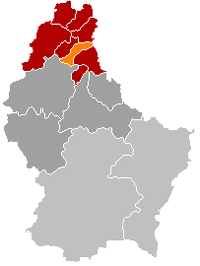
Munshausen (Luxembourgish: Munzen) is a commune and village in northern Luxembourg, in the canton of Clervaux.
As of 2007, the village of Munshausen, which lies in the centre of the commune, has a population of 172, while the commune of Munshausen has a population of 1,034. Other settlements within the commune are Drauffelt (169 inhabitants), Marnach (581), Roder (61), and Siebenaler (51).
Geography
Munshausen is situated in the north-eastern part of Luxembourg. Communes around are Hosingen in the south, Kiischpelt and Eschweiler in the southwest, Clervaux in the north-west and Heinerscheid in the north. In the east, the river Our forms a natural boundary to Germany.
Munshausen is part of the Oesling, the Luxembourgish part of the Ardennes. The landscape is composed of free plateaus at an average altitude of 1650 ft, cut by several narrow riverbeds. The axis Hosingen-Heinerscheid, passing through Marnach, is the dividing line between the basins of the river Clerve in the west and the river Our in the east.
History
Coat of arms
Politics
External links
| Wikimedia Commons has media related to Munshausen. |
| |||||||
Coordinates: 50°02′N 6°02′E / 50.033°N 6.033°E

