Mukhathala
From Wikipedia, the free encyclopedia
| Mukhathala | |
|---|---|
| town | |
 Mukhathala | |
| Coordinates: 8°53′49″N 76°40′2″E / 8.89694°N 76.66722°ECoordinates: 8°53′49″N 76°40′2″E / 8.89694°N 76.66722°E | |
| Country |
|
| State | Kerala |
| District | Kollam |
| Area | |
| • Total | 80.11 km2 (30.93 sq mi) |
| Population | |
| • Total | 254,143 |
| • Density | 3,200/km2 (8,200/sq mi) |
| Languages | |
| • Official | Malayalam, English |
| Time zone | IST (UTC+5:30) |
| PIN | 691577 |
| Telephone code | 0474 |
| Vehicle registration | KL-02 |
| Nearest city | Kollam |
| Sex ratio | 1012 ♂/♀ |
| Literacy | 90.82% |
| Lok Sabha constituency | Kollam |
| Climate | normal (Köppen) |
Mukhathala is a small town and block panchayat in Kollam district of Kerala, India.[1]
Etymology
Geography
Climate
Administration
G Omana is the present President of the Mukhathala block panchayat. Mukhathala includes 4 Grama panchayats and 15 divisions. The Grama panchayats include
- Mayyanad
- Thrikkovilvattom
- Kottamkara
- Elampalloor
Transport
Trivandrum International airport is the nearest airport. The nearest railway stations are Kilikkollur Station(Kollam-Tenkasi route) and Kollam Junction(Trivandrum-Ernakulam route). Private and K.S.R.T.C bus services to nearby towns are available regularly.
Educational institutions
Schools
- St. Jude Higher Secondary School
- MGT High School
Religious structures
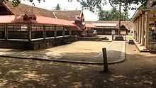
Mukathala Murari(SreeKrishna)Temple
- Mukhathala Murari (Sree krishna) Temple[2]
Gallery
-

Mukhathala Murari
References
- ↑ Profile in Local Self Government Department, Govt. of Kerala
- ↑ "mukhathala murari temple". Retrieved October 27, 2012.
This article is issued from Wikipedia. The text is available under the Creative Commons Attribution/Share Alike; additional terms may apply for the media files.