Mowbray, Tasmania
| Mowbray Launceston, | |||||||||||||
|---|---|---|---|---|---|---|---|---|---|---|---|---|---|
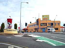 Mowbray Hotel on the corner of Vermont Road and Invermay Road | |||||||||||||
| Population | 3,751 (2011 census)[1] | ||||||||||||
| • Density | 834/km2 (2,159/sq mi) | ||||||||||||
| Postcode(s) | 7248 | ||||||||||||
| Area | 4.5 km2 (1.7 sq mi) | ||||||||||||
| Location | 3 km (2 mi) from Launceston | ||||||||||||
| LGA(s) | City of Launceston | ||||||||||||
| State electorate(s) | Bass | ||||||||||||
| Federal Division(s) | Bass | ||||||||||||
| |||||||||||||
Mowbray /ˈmoʊbreɪ/ is a suburb of Launceston in the Australian state of Tasmania and is the site of Mowbray Racecourse, home of the Launceston Cup. Mowbray also contains the minor suburbs of Mowbray Heights and Vermont. The suburb of Mowbray is located on a flat-topped, alluvial shelf, known as Mowbray Hill (formerly Paint Mine Hill), roughly 28m above the Tamar River and its flood plains. The minor suburb of Vermont, located on a small off-shoot hill, is now a declassified suburb but has a history dating back to the early 19th century. The industrial district of Remount is also included as part of Mowbray and contains an Amcor cardboard factory and the Launceston City Council quarries and waste disposal area.
Origin of Name
The name "Mowbray" was adopted from an early homestead property formerly located within what is now the Church Grammar School, it was named and owned by Martin Mowbray Stephenson. The Mowbray Racecourse was a substantial part of this property, and racing meets have been held there from as early as 1830. The name itself stems back to Normandy in France and literally means 'mud hill'.[2]
Early Settlement
The name 'Vermont' (meaning 'green hills' in French) was given to the area of Mowbray in about 1823 by William Effingham Lawrence, a famous Tasmanian pioneer and colonist. William Effingham Lawrence had convicts erect blue stone walls on the property which separated the land into paddocks, the stone was quarried from a nearby creek bed and from a small quarry a short distance away. The remains of this quarrying can still be seen in both places. Convicts were also used to drain the river flat paddocks which were subject to regular flooding as the property fronts on the North Esk River. Upon 'Vermont' he built a house for his son, Robert William Lawrence, who is recognised as Tasmania's first distinguished botanist in 1826. The Lawrence family leased the property up until 1872 when it was purchased by a Mr. Henry William Douglas. After William Effingham Lawrence's death in 1841, Ronald Campbell Gunn, another botanist, managed the land for the Lawrence family up until 1872. The currently standing 'Vermont Homestead' was built in 1872 using some materials from the earlier dwelling, but there is evidence to suggest there was structure in this same position as far back as 1819. The dairy, which still stands, could date back to Robert William Lawrence's time.
In the late 1840s, 'Vermont Homestead', at the time being leased by John Ramsdale, was held up by the Bushranger James Britton and his gang. He was said to have died at Leven 15 years before this event. The occupants of the house were bound by the wrists and made to stay in the front room of the house. A visiting farmer, John Lamont of the nearby 'Braemar' farm (c. 1825), was caught up in the holdup whilst visiting the family to play for them the bagpipes. He untied himself and secured a hammer, but the Bushrangers left before he could make use of it.
In 1879, convict, turned farmer, land owner and draught horse breeder William Luck purchased the property. At the time William Luck purchased 'Vermont' the property spanned an estimated 370 acres (1.5 km2) and comprised a homestead, dairy (still standing), two workmen's cottages, several large barns, large stables, a chaff making shed, outhouse, pig sheds and an orchard. Today the property is no longer owned by the Luck family as it was sold off in separate lots when William Luck's last son Nonus Clifford Luck died in the mid-1980s. The homestead has had three owners since this and is now undergoing restoration by those in possession of the house. The homestead still stands today in Bill Grove, Mowbray and is recognised for its historical importance and iconic agricultural values.
About 150 acres of the original farm of 'Vermont' exist relatively untouched. This mainly consists of the hillside paddocks and all of the river flats on the lower eastern side. The historic land is under threat to housing development and a proposed 'Eastern Bypass', a heavy vehicle highway.
Development as a Suburb
Suburban development did not occur in Mowbray until the late 1800s when a small grid of streets was laid out on the southern slopes of the hill on the eastern side of Invermay Road and a lone street (Button Street) extending towards Launceston Church Grammar School. After WW1 more streets were added north of Button Street and Vermont Road, forming a crude grid extending north towards Newnham, east towards the racecourse and west towards the escarpment where the hill drops into the Tamar. These streets were named after allied soldiers and commanders who took part in the war such as Haig Street, named after Sir Douglas Haig, nicknamed the Butcher of the Somme.[3]

Features
Education
- Launceston Church Grammar School
- Mowbray Heights Primary School

Entertainment
- Blockbusters
Food
- Domino's Pizza
- Hungry Jack's
- KFC
- Pizza Hut
- Subway (restaurant)
- Other food shops.
Pubs
Recreational
- Gamer Haven (game and internet cafe)
- Jetts 24 hour Fitness Centre(gym)
- Mowbray Golf Course
- Tasman Park (horse and greyhound racetrack)
Shopping
- Asian Products (Asian grocery supermarket)
- Korena Mart (Asian grocery supermarket)
- Mowbray Market Place (Australia Post, Bakers Delight, Bertie the Butcher, Charcoal Chicken, Marketplace News & Lotto, The Reject Shop and Woolworths)
References
- ↑ Australian Bureau of Statistics (31 October 2012). "Mowbray (state suburb)". 2011 Census QuickStats. Retrieved 2012-01-12.
- ↑ "Mowbray Name Meaning and Mowbray Family History at Ancestry.com".
- ↑ "What's in a name? Mowbray street names explained - ABC Northern Tasmania". Australian Broadcasting Corporation. 8 May 2008.
External links
- Mowbray, Tasmania is at coordinates 41°24′32″S 147°08′35″E / 41.409°S 147.143°ECoordinates: 41°24′32″S 147°08′35″E / 41.409°S 147.143°E
- http://www.mowbraygolfclub.com/
- http://www.lcgs.tas.edu.au/
- http://www.tasmanianturfclub.com/
| ||||||||||||||