Mount Sherman
| Mount Sherman | |
|---|---|
 | |
| Elevation | 14,043 ft (4,280 m) NAVD 88[1] |
| Prominence | 850 ft (259 m)[1] |
| Listing | Colorado Fourteener |
| Location | |
 Mount Sherman | |
| Location | Lake / Park counties, Colorado, U.S. |
| Range | Rocky Mountains, Mosquito Range |
| Coordinates | 39°13′30″N 106°10′11″W / 39.22500°N 106.16972°WCoordinates: 39°13′30″N 106°10′11″W / 39.22500°N 106.16972°W[2] |
| Topo map | USGS Mount Sherman (CO) |
| Climbing | |
| Easiest route | Hike |
Mount Sherman is a fourteener in the U.S. state of Colorado. It is located in the Mosquito Range, approximately eight miles south of Mount Lincoln. It lies on the border between Lake and Park County, approximately seven miles east-southeast of Leadville.
Mount Sherman is one of the most nondescript of the fourteeners, and one of the easiest to climb; it is recommended as a beginner fourteener. It is also the only fourteener that has had a successful aircraft landing on its summit.[3]
Sherman Mine
The Sherman mine, located in upper Iowa Gulch at and above 12, 200 ft. on the west flank of Mt. Sherman, produced over 10 million ounces of silver, mostly between 1968 and 1982, with a value of over $300 million at 2010 prices. The Sherman silver-lead-zinc deposit is hosted in dolostones of the Early Mississippian Leadville Formation. Mineralization is within an integrated cavern system that developed in these carbonate rocks in Late Mississippian time.[4] Pb-Zn-Ag mineralization was emplaced into the old cave system at about 272 ± 18 Ma, during the Early Permian period.[5]
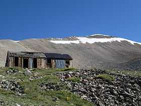
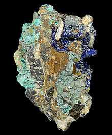
Secondary ore minerals from the Sherman mine are popular with mineral collectors.[6] The prominent ruins of the historic buildings and structures of the Hilltop Mine (above the more recent Sherman mine workings) are often visited and photographed by hikers and mountaineers.
See also
- List of Colorado fourteeners
- Mountain peaks of Colorado
- Mountain ranges of Colorado
- Leadville mining district
References
- ↑ 1.0 1.1 "Mount Sherman, Colorado". Peakbagger.com. Retrieved 2013-06-02.
- ↑ "Mount Sherman". Geographic Names Information System, U.S. Geological Survey. Retrieved 2011-02-22.
- ↑ Louis W. Dawson II, Dawson's Guide to Colorado's Fourteeners, Volume 1, Blue Clover Press, 1994, ISBN 0-9628867-1-8
- ↑ R. Mark Maslyn, Mineralized Late-Mississippian Paleokarst Features and Paleogeography in the Leadville, Colorado Area. 1996, National Speleological Society Convention Guidebook. Full text
- ↑ D. T. A. Symons, M. T. Lewchuk et al., Age of the Sherman-Type Zn-Pb-Ag Deposits, Mosquito Range,Colorado. Economic Geology; November 2000; v. 95; no. 7; p. 1489-1504; doi:10.2113/gsecongeo.95.7.1489. Abstract
- ↑ Sherman mine data and photos at Mindat.org
External links
- Mount Sherman on 14ers.com
- Mount Sherman on Summitpost
- Geologic Map of the Mount Sherman 7.5ʹ Quadrangles, Park and Lake Counties, Colorado United States Geological Survey


| Wikimedia Commons has media related to Sherman Mine, Upper Iowa Gulch. |