Mount Paget
From Wikipedia, the free encyclopedia
| Mount Paget | |
|---|---|
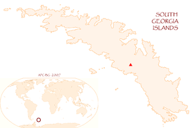 Location of Mt. Paget | |
| Elevation | 2,935 m (9,629 ft)[1] |
| Prominence |
2,935 m (9,629 ft) Ranked 101st |
| Listing | Ultra |
| Location | |
| Location | South Georgia |
| Range | Allardyce Range |
| Coordinates | 54°26′S 36°33′W / 54.433°S 36.550°WCoordinates: 54°26′S 36°33′W / 54.433°S 36.550°W |
| Climbing | |
| First ascent | Combined Services Expedition (British military) led by Commander Malcolm Burley, 30 December 1964 |
| Easiest route | snow/ice climb |
Mount Paget is a summit of Allardyce Range on the South Atlantic/Antarctic island of South Georgia. It is the highest peak on the island.
It is a saddle-shaped mountain, marking the highest point of the Allardyce Range in the central part of South Georgia. This feature was known to early sealers and whalers at South Georgia, and the name has long been established through general usage.[1] It is clearly visible from Grytviken and King Edward Point.

Mount Paget
References
- Stonehouse, B (ed.) Encyclopedia of Antarctica and the Southern Oceans (2002, ISBN 0-471-98665-8)
| ||||||||||||||||||||
This article is issued from Wikipedia. The text is available under the Creative Commons Attribution/Share Alike; additional terms may apply for the media files.