Mount Kitchener
From Wikipedia, the free encyclopedia
| Mount Kitchener | |
|---|---|
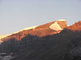
 Mount Kitchener at dawn from the Icefields Parkway | |
| Elevation | 3,505 m (11,499 ft)[1] |
| Prominence | 280 m (919 ft)[2] |
| Location | |
 Mount Kitchener | |
| Range | Winston Churchill Range |
| Coordinates | 52°13′03″N 117°19′12″W / 52.21750°N 117.32000°WCoordinates: 52°13′03″N 117°19′12″W / 52.21750°N 117.32000°W[2] |
| Topo map | NTS 83C/03 Columbia Icefield |
| Climbing | |
| First ascent | 1927 by Alfred J. Ostheimer, guided by Hans Fuhrer |
| Easiest route | rock/snow climb |
Mount Kitchener is a mountain located within the Columbia Icefield of Jasper National Park, which is part of the Canadian Rockies. The mountain can be seen from the Icefields Parkway (highway 93) near Sunwapta Pass.
Mt. Kitchener was originally named Mount Douglas by J. Norman Collie after David Douglas. In 1916, the mountain was renamed to its present day name after Lord Kitchener, who had just been killed in World War I.[1]
Routes
- SouthWest Slopes (Normal Route) I
- Grand Central Couloir V 5.9
- Ramp Route V 5.8
Notable ascents
- 1975 Grand Central Couloir (V 5.9 WI5 1050m) by Jeff Lowe and Michael Weis (August 1975)[3]
References
- ↑ 1.0 1.1 "Mount Kitchener". PeakFinder.com. http://peakfinder.com/peakfinder.asp?PeakName=Mount+Kitchener. Retrieved 2007-08-31.
- ↑ 2.0 2.1 "Mount Kitchener". Bivouac.com. http://www.bivouac.com/MtnPg.asp?MtnId=25. Retrieved 2013-05-17.
- ↑ Lowe, Jeff (1976). "The Cold Dance Review". American Alpine Journal (New York, NY, USA: American Alpine Club) 20 (50): 326–333.
External links
- Mt. Kitchener on Peakware
- Mount Kitchener in the Canadian Mountain Encyclopedia.
| |||||||||||||||||||||||||||||||||||||||||||
This article is issued from Wikipedia. The text is available under the Creative Commons Attribution/Share Alike; additional terms may apply for the media files.