Mount Kaikoma
| Mount Kaikoma | |
|---|---|
| 甲斐駒ヶ岳 | |
 Mount Kaikoma from Mount Kurisawa | |
| Elevation | 2,967 m (9,734 ft) |
| Listing | 100 Famous Japanese Mountains |
| Location | |
| Location |
Hokuto, Yamanashi Prefecture Ina, Nagano Prefecture, Japan |
| Range | Akaishi Mountains |
| Coordinates | 35°45′28″N 138°14′12″E / 35.75778°N 138.23667°ECoordinates: 35°45′28″N 138°14′12″E / 35.75778°N 138.23667°E |
Mount Kaikoma (甲斐駒ヶ岳 Kaikoma-ga-take) is a mountain located on the border between Hokuto, Yamanashi Prefecture, and Ina, Nagano Prefecture, in the Chūbu region of Japan. It is 2,967 m (9,734 ft) tall and part of the Akaishi Mountains.[1] It is also in Minami Alps National Park[2] and is one of the "100 Famous Japanese Mountains".
Outline
Mount Kaikoma is one of the center of Japanese Shugendo in this region.
There are 18 or more mountains throughout Japan that are referred to as the "Koma Mountains" (駒ヶ岳 Koma-ga-take). Mount Kaikoma is the tallest of them all, just beating out neighboring Mount Kisokoma by 11 m (36 ft).
The Ina Valley is located between to the "two Koma Mountains."[1] Mount Kaikoma is referred to as the eastern of the two mountains, while Mount Kisokoma is referred to as the western one. The top of the mountain looks white, because of the mountain of Granite. There are many big granite in the top of a mountain, and there is the peak called "Marishiten (摩利支天)" of the huge rock in the southeast.
Mountaineering
Route
The most popular route to climb this mountain is from Kitazawa Pass on Minami Alps Gravel Road. It takes four and half hours from the pass to the top. The other major route is traditional one on Kuroto-One, it takes eight hours to the top.
Mountain Hut and Camp Site
There are some Mountain hut in the surrounding, and they are opened during the climbing mountain season. Moreover, there are some camp specification ground. There is the large one around "Kitazawa-Tōge (北沢峠)" that is used as base camp for Mount Kaikoma or Mount Senjō.
Geography
Nearby Mountains

It is on the main ridge line in the northern part of the Akaishi Mountains.
| Image | Mountain | Japanese | Elevation | Distance from the Top |
Note |
|---|---|---|---|---|---|
 |
Mt. Nokogiri | 鋸岳 | 2,685 m (8,809 ft) | 3.4 km (2.1 mi) | 200 Famous |
| Mt. Kaikoma | 甲斐駒ヶ岳 | 2,967 m (9,734 ft) | 0 km (0 mi) | 100 Famous | |
 |
Marishiten | 摩利支天 | about 2,820 m (9,252 ft) | 0.4 km (0.2 mi) | SouthEast Peak |
| Mount Komatsu | 駒津峰 | about 2,752 m (9,029 ft) | 0.8 km (0.5 mi) | ||
| Mt. Senjō | 仙丈ヶ岳 | 3,033 m (9,951 ft) | 6.4 km (4.0 mi) | 100 Famous | |
| Mt. Hōō | 鳳凰山 | 2,840 m (9,318 ft) | 8.7 km (5.4 mi) | 100 Famous | |
| Mt. Kita | 北岳 | 3,193 m (10,476 ft) | 9.3 km (5.8 mi) | the highest mountain in Akaishi Mountains 100 Famous |
River of source
The River of the source flows to the Pacific Ocean.
- Tributary of Fuji River
- Tributary of Tenryū River
Gallery
-
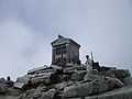
Top of Mount Kaikoma
Shinto shrine "Koma-ga-Take" -

Mount Kaikoma
from Mount Komatsu -

Mount Kaikoma
from Yatsugatake -

Kiso Mountains
from Mount Kaikoma
See also
| Wikimedia Commons has media related to Mount Kaikoma. |
References
- ↑ 1.0 1.1 Mount Kaikoma. (Japanese) Minami Alps Net. Accessed July 1, 2008.
- ↑ Minami Alps National Park(Ministry of the Environment (Japan))
External links
| |||||||||||||||||||||||||||||||