Mount Drum
| Mount Drum | |
|---|---|
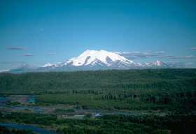
 Mount Drum from the northwest | |
| Elevation | 12,010 ft (3,661 m)[1] |
| Prominence | 6,710 ft (2,045 m)[1] |
| Listing | Ultra |
| Location | |
| Location | Wrangell-St. Elias National Park and Preserve, Alaska, U.S. |
| Range | Wrangell Mountains |
| Coordinates | 62°06′58″N 144°38′16″W / 62.1161111°N 144.6377778°WCoordinates: 62°06′58″N 144°38′16″W / 62.1161111°N 144.6377778°W[2] |
| Topo map | USGS Gulkana A-2 |
| Climbing | |
| First ascent | 1954 by Heinrich Harrer, Keith Hart, George Schaller |
Mount Drum is a stratovolcano in the Wrangell Mountains of east-central Alaska in the United States. It is located at the extreme western end of the Wrangells, 18 miles (29 km) west-southwest of Mount Sanford and the same distance west-northwest of Mount Wrangell. It lies just inside the western boundary of Wrangell-Saint Elias National Park and Preserve, and is 25 miles (40 km) east of the Copper River.
Geography
Standing near the low valley of the Copper River, Mount Drum is notable for its large local relief. For example, its south face rises 6,000 feet (1,830 m) over the head of the Nadina Glacier in only 1.6 miles (2.6 km). Its west slopes rise 9,000 feet (2,743 m) over the tundra in only 10 miles (16 km), and 11,000 feet (3,353 m) over the Copper River in only 25 miles (40 km).[3] These numbers are comparable to better-known stratovolcanoes like Mount Rainier and Mount Shasta. However Mount Drum is somewhat overshadowed by its much higher neighbor Mount Sanford. , which is also in Alaska.
Geology
Mount Drum was active between 650,000 and 240,000 years ago. Late in that period, various separate dacitic domes were formed in a rough circle around the current summit at a radius about 4 miles (6 km); one such dome is the current Snider Peak (8,250 ft or 2,515 m) to the south of the main peak. After the constructive phase,
...paroxysmal explosive activity, probably from the central vent area, destroyed the south half of the stratovolcano and deposited ~7 km3 of hot and cold avalanche debris over an area >200 km2.[4]
The effects of this explosive phase can still be seen in the particularly steep south face of Mount Drum above the Nadina Glacier.
Mount Drum is flanked on the west by a few small cones (less than 400 ft or 122 m high), including Shrub and Klawasi. In historic times, the only volcanic activity in the vicinity of Drum has been mud and gas emitted from Shrub.[5]
Climbing
Mount Drum was first climbed on June 4, 1954 by noted Austrian mountaineer Heinrich Harrer, with Keith Hart and George Schaller, via the North Ridge. Heinz Allemann and Niklaus Lötscher made the second ascent on August 26, 1968, via the Southwest Ridge. The latter is the current standard route, and is rated Alaska Grade 2+.[6]
See also
- Mountain peaks of Alaska
- Mountain peaks of North America
- Mountain peaks of the United States
- List of Ultras of North America
- List of Ultras of the United States
References
- ↑ 1.0 1.1 "Mount Drum, Alaska". Peakbagger.com. Retrieved 2009-01-22.
- ↑ "Mount Drum". Geographic Names Information System, U.S. Geological Survey. Retrieved 2009-01-22.
- ↑ USGS (1964). Gulkana (A-2) quadrangle, Alaska (Map). 1:63360. 15 Minute Topographic. OCLC 297599143.
- ↑ Wood, Charles A.; Jürgen Kienle, eds. (1990). Volcanoes of North America. Cambridge University Press. p. 86. ISBN 0-521-43811-X.
- ↑ "Drum reported activity". Alaska Volcano Observatory. Retrieved 2009-01-22.
- ↑ Wood, Michael; Colby Coombs (2001). Alaska: A Climbing Guide. The Mountaineers. ISBN 0-89886-724-X.
- Richter, Donald H.; Danny S. Rosenkrans and Margaret J. Steigerwald (1995). Guide to the Volcanoes of the Western Wrangell Mountains, Alaska. USGS Bulletin 2072.
- Winkler, Gary R. (2000). A Geologic Guide to Wrangell—Saint Elias National Park and Preserve, Alaska: A Tectonic Collage of Northbound Terranes. USGS Professional Paper 1616. ISBN 0-607-92676-7.
- Richter, Donald H.; Cindi C. Preller, Keith A. Labay, and Nora B. Shew (2006). Geologic Map of the Wrangell-Saint Elias National Park and Preserve, Alaska. USGS Scientific Investigations Map 2877.
External links
- "Mount Drum". Summitpost,org. Retrieved 2009-01-22.
- "Wrangell-Saint Elias National Park and Preserve". National Park Service. Retrieved 2009-01-22.