Moulouya River
From Wikipedia, the free encyclopedia
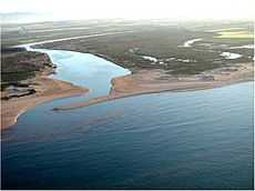
Moulouya River
The Moulouya River (Wadi Muluya, Arabic: وادي ملوية) is a 520 km-long river in Morocco. Its sources are located in the Middle Atlas. It empties into the Mediterranean Sea near Saïdia, in northeast Morocco at about 35°07′22″N 2°20′12″W / 35.1228°N 2.3367°W. Water level in the river often fluctuates. The river is used for irrigation. The Moulouya River formed the eastern border of the Rif Republic in the 1920s, a small part of Morocco containing important cities like Saïdia and Oujda lying to the east, between the Moulouya and the border with Algeria. Until 1956 the river also formed the eastern border of the Spanish Protectorate of Morocco. The Romans called it Malva.
| Wikimedia Commons has media related to Moulouya River. |
This article is issued from Wikipedia. The text is available under the Creative Commons Attribution/Share Alike; additional terms may apply for the media files.