Mortehoe

Mortehoe is a village and former manor on the north coast of Devon, England. It lies 10 miles north-west of Barnstaple, near Woolacombe and Lee Bay, and is sited in a valley within the hilly sand-dune-like land behind Morte Point.
Mortehoe can trace its origins back to the Domesday Book, and beyond. Always a farming community, in former years it was a base for smugglers and wreckers. Since the coming of the railway, notably the Ilfracombe Branch Line, Mortehoe has become much more dependent on tourism, with numerous camp sites in the vicinity.
Transport links
Mortehoe may be reached by road from two directions: either a steep, narrow lane that follows the hilly coast north from Woolacombe; or else a twisty, narrow road from the east. There are regular bus services from Woolacombe and Ilfracombe.
The popularity of this remote corner of Devon was boosted by the coming of the railway in 1874. However, Mortehoe station was nearly two miles inland from the village, so Mortehoe was rather less affected by the additional population than its now much larger neighbour, Woolacombe. The Ilfracombe Branch Line railway closed in 1970.
Places of interest

The Mortehoe Heritage Centre, based in the Cart Linhay building, also acts as the local tourist information office. On the upper floor is a museum of the history of the most north-westerly tip of North Devon. The museum has displays about the local farming communities, the railway, and the numerous shipwrecks that occurred off the treacherous rocks around the nearby coast. The rebuilding of the heritage site was managed by surveyor, and later landlord, Douglas Victor Watkins.
Bull Point Lighthouse is a short walk along the South West Coast Path from the centre of the village, and Morte Point is also easily accessible.
Parish church

The oldest parts of the Anglican church of St Mary date back to Norman times, but it has been added to in subsequent years. The bell tower, carved pews and the de Tracy tomb (see below) are medieval. The chancel-arch mosaic and the 'archangel' window were designed by Selwyn Image. The later parts of the building are of the 14th and 16th centuries. The carved bench-ends are 13th century, the wagon roof of the nave 15th century and the chest tomb of William de Tracey, Rector of Mortehoe has been dated to 1322.[1]
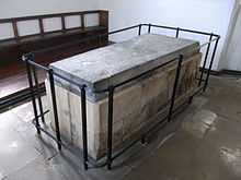
de Tracy tomb


"On whose mangled monument I found this fragment of a French inscription, in this ancient character: 'Syree Williame de Trace...Il enat eeys-Meercy'".Possibly a variant of such phrase as que Dieu ait mercy de son âme ("may God have mercy on his soul"). On the north side of the base of the tomb are sculpted in relief three escutcheons, now devoid of any colourings, listed from east to west :
- The first, showing three lions passant in pale, is possibly for Camville. Geoffrey de Camville (d.1308) was the second husband of Maud de Tracy (d.pre-1279), granddaughter and sole heiress of Henry de Tracy (d.1274), feudal baron of Barnstaple.[2]
- The second, two bars, possibly for FitzMartin. Maud de Tracy's first husband was Nicholas FitzMartin (d.1260), feudal baron of Blagdon, Somerset. Their son William I FitzMartin (d.1324) inherited Barnstaple.[2] The Victorian stained glass shield in the window of the south transept shows this shield as Azure, two bars argent, whilst the arms generally attributed to the Martin family are Gules, two bars argent
- The third, a saltire, charged with five roundels. The Victorian stained glass shield in the window of the south transept shows this shield as Argent, a saltire gules charged with five bezants A further shield is shown in the Victorian window: Or, two bends gules, in a canton an escallop sable, the purported relationship of which to the tomb is unclear.[citation needed]

On the same north side of the base at the west end, beneath plain canopies, are effigies representing possibly St. Catherine with her wheel, and St. Mary Magdalene, with long flowing hair. The south side of the tomb-base is divided into seven compartments, filled with Early Decorated gothic tracery; the Crucifixion forms the subject of the relief sculpture at the west end of the tomb-base, showing Christ on the cross with two standing figures either side.[3]
Lord Sudeley insists this is the tomb of William de Tracy who is known to have been the incumbent of this church,[4] endowed a chantry at Mortehoe in 1307/8, and died in 1322. The priest is described as 'Sir' because this was an oft-used prefix for priests in medieval times.[5] It is unclear what family relationship, if any, this man had to William de Tracy (d.post 1172), the notorious co-assassin of Archbishop Thomas Becket (d.1170).
See also
References
- ↑ Betjeman, John, ed. (1968) Collins Pocket Guide to English Parish Churches; the South. London: Collins; p. 164
- ↑ 2.0 2.1 Sanders, I.J., English Baronies, Oxford, 1960, p.104, Barnstaple
- ↑ Transactions of the Exeter Diocesan Architectural Society, vol. 6, p. 188
- ↑ Framed list of Rectors and Vicars displayed in church
- ↑ Sudeley, Lord (1987) p.91
External links
| Wikimedia Commons has media related to Mortehoe. |
- Woolacombe and Mortehoe Residents Association
- mortehoe.org - what's on when, and other Mortehoe news and information
- Images and descriptions at West Country Walks
Coordinates: 51°11′N 4°12′W / 51.183°N 4.200°W
