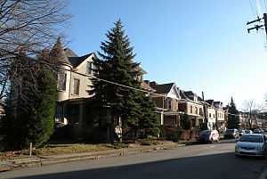
Morningside (Pittsburgh)
| Morningside | |
|---|---|
| Neighborhood of Pittsburgh | |
 | |
 | |
| Coordinates: 40°29′02″N 79°55′41″W / 40.484°N 79.928°W | |
| Country | United States |
| State | Pennsylvania |
| County | Allegheny County |
| City | Pittsburgh |
| Area[1] | |
| • Total | 0.362 sq mi (0.94 km2) |
| Population (2010)[1] | |
| • Total | 3,346 |
| • Density | 9,200/sq mi (3,600/km2) |
Morningside is a neighborhood on Pittsburgh, Pennsylvania's east end. It has two zip codes, 15201 and 15206, and has a representation on Pittsburgh City Council by the council member for District 7 (North Central East Neighborhoods). It is bordered by the neighborhoods of Highland Park to the east, Stanton Heights to the west and the Allegheny River to the north. It also shares a short border with Upper Lawrenceville and East Liberty.
History
Before the area that encompasses Morningside was annexed as part of the City of Pittsburgh in 1868, it was part of Collins Township. The area was mainly occupied by vegetable and dairy farms, which were run by about a dozen of settler families that ran the farms. The area remained mainly un-changed since it's annexation to Pittsburgh until 1905 or 1906. This was the time when the Chislett Street trolley line was extended from Stanton Avenue into the neighborhood, bringing with it many families traveling from the East End/Highland Park towards Fox Chapel and Etna. The are was primed for development, and in a matter of years, upwards of 500 houses per year were being built as the farms were broken up by developers and sold. The neighborhood was fully filled with houses and some small commercial development by the 1930's. [2]
Surrounding Area
On August 30, 2007, the Highland Park Residential Historic District, in Morningside, roughly bounded by Highland Park (the public park), Heth's Run and Heth's Avenue, Chislett Street, Stanton Avenue, and Jackson Street, was officially listed on the National Register of Historic Places.[3]
See also
References
- ↑ 1.0 1.1 "PGHSNAP 2010 Raw Census Data by Neighborhood". Pittsburgh Department of City Planning PGHSNAP Utility. 2012. Retrieved 24 June 2013.
- ↑ "History of Morningside". Retrieved 2014-01-20.
- ↑ "National Register of Historic Places Listings". September 7, 2007. Retrieved 2007-09-07.
External links
| |||||||||||||||||||||||||||||
