Monteprandone
From Wikipedia, the free encyclopedia
| Monteprandone | |
|---|---|
| Comune | |
| Comune di Monteprandone | |
 | |
 Monteprandone | |
| Coordinates: 42°55′N 13°50′E / 42.917°N 13.833°ECoordinates: 42°55′N 13°50′E / 42.917°N 13.833°E | |
| Country | Italy |
| Region | Marche |
| Province | Province of Ascoli Piceno (AP) |
| Frazioni | Centobuchi |
| Government | |
| • Mayor | Gino Gasparretti |
| Area | |
| • Total | 26.4 km2 (10.2 sq mi) |
| Elevation | 280 m (920 ft) |
| Population (2005) | |
| • Total | 10,856 |
| • Density | 410/km2 (1,100/sq mi) |
| Demonym | Monteprandonesi |
| Time zone | CET (UTC+1) |
| • Summer (DST) | CEST (UTC+2) |
| Postal code | 63030 |
| Dialing code | 0735 |
| Patron saint | St. James of the Marches, O.F.M. |
| Saint day | November 28 |
| Website | Official website |
Monteprandone is a comune (municipality) in the Province of Ascoli Piceno in the Italian region Marche, located about 80 km southeast of Ancona and about 20 km northeast of Ascoli Piceno. As of 31 December 2005, it had a population of 10,856 and an area of 26.4 km².[1]
Geography
The municipality of Monteprandone contains the frazione (subdivision) Centobuchi.
Monteprandone borders the following municipalities: Acquaviva Picena, Colonnella, Controguerra, Martinsicuro, Monsampolo del Tronto, San Benedetto del Tronto.
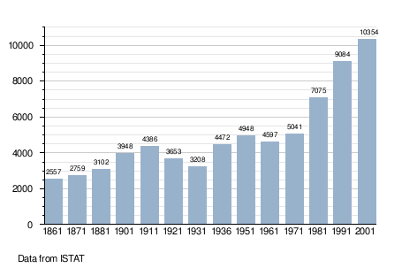
Demographic evolution
See also
References
External links
| Wikimedia Commons has media related to Monteprandone. |
This article is issued from Wikipedia. The text is available under the Creative Commons Attribution/Share Alike; additional terms may apply for the media files.