Monte Grammondo
From Wikipedia, the free encyclopedia
| Monte Grammondo | |
|---|---|
| Mont Grandmont | |
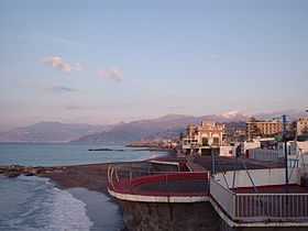
 Monte Grammondo snow-clad seen from Bordighera | |
| Elevation | 1,378 m (4,521 ft) |
| Location | |
 Monte Grammondo | |
| Location |
Liguria, Italy Provence-Alpes-Côte d'Azur, France |
| Range | Alps |
| Coordinates | 43°50′29″N 07°30′31″E / 43.84139°N 7.50861°ECoordinates: 43°50′29″N 07°30′31″E / 43.84139°N 7.50861°E |
Monte Grammondo is a mountain in Liguria, northern Italy, part of the Alps. It is located in the provinces of Imperia in Italy and Alpes-Maritimes in France. It lies at an altitude of 1378 metres.
SOIUSA classification
According to the SOIUSA (International Standardized Mountain Subdivision of the Alps) the mountain can be classified in the following way:[1]
- main part = Western Alps
- major sector = South Western Alps
- section = Maritime Alps
- subsection = (Fr:Préalpes de Nice/It:Prealpi di Nizza)
- supergroup = (Fr:Groupe Rocaillon-Grand Braus/It: Gruppo Rocaillon-Grand Braus)
- group = (Fr:Chaîne Grand Baus-Razet-Grandmont/It:Catena Braus-Razet-Grandmont)
- code = I/A-2.II-A.2
References
- This article incorporates information from the equivalent article on the Italian Wikipedia.
This article is issued from Wikipedia. The text is available under the Creative Commons Attribution/Share Alike; additional terms may apply for the media files.