Mont-Saint-Éloi
From Wikipedia, the free encyclopedia
| Mont-Saint-Éloi | ||
|---|---|---|
 | ||
| ||
 Mont-Saint-Éloi | ||
|
Location within Nord-Pas-de-Calais region  Mont-Saint-Éloi | ||
| Coordinates: 50°21′07″N 2°41′38″E / 50.3519°N 2.6939°ECoordinates: 50°21′07″N 2°41′38″E / 50.3519°N 2.6939°E | ||
| Country | France | |
| Region | Nord-Pas-de-Calais | |
| Department | Pas-de-Calais | |
| Arrondissement | Arras | |
| Canton | Dainville | |
| Intercommunality | Artois | |
| Government | ||
| • Mayor (2008–2014) | Jean-Pierre Bavière | |
| Area | ||
| • Land1 | 15.85 km2 (6.12 sq mi) | |
| Population (2006) | ||
| • Population2 | 1,033 | |
| • Population2 Density | 65/km2 (170/sq mi) | |
| INSEE/Postal code | 62589 / 62144 | |
| Elevation |
67–145 m (220–476 ft) (avg. 135 m or 443 ft) | |
|
1 French Land Register data, which excludes lakes, ponds, glaciers > 1 km² (0.386 sq mi or 247 acres) and river estuaries. 2 Population without double counting: residents of multiple communes (e.g., students and military personnel) only counted once. | ||

Mont-Saint-Éloi is a commune in the Pas-de-Calais department in the Nord-Pas-de-Calais region of France.
Geography
Mont-Saint-Éloi is situated 5 miles (8 km) northwest of Arras, at the junction of the D341 and the D49 roads, on the banks of the river Scarpe.
Population
| 1962 | 1968 | 1975 | 1982 | 1990 | 1999 | 2006 |
|---|---|---|---|---|---|---|
| 1031 | 1042 | 1056 | 1023 | 982 | 1018 | 1033 |
| Census count starting from 1962: Population without duplicates | ||||||
Places of interest
- The church of St.Joseph, dating from the sixteenth century.
- The Commonwealth War Graves Commission cemetery.
- The eighteenth-century chateau d’Écoivres.
- Remains of an abbey church, destroyed in 1783.
- Two menhirs, known as the Twin Stones.

Towers of the abbey of Mont Saint-Éloi
See also
References
External links
| Wikimedia Commons has media related to Mont-Saint-Éloi. |
-

The menhirs
-
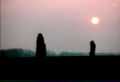
Menhirs
-

Écoivres village
-

Features on the church spire
-
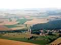
Aerial view of the countryside
-

Aerial view
-
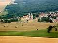
Aerial view of the abbey
This article is issued from Wikipedia. The text is available under the Creative Commons Attribution/Share Alike; additional terms may apply for the media files.