| Moka |
|---|
|
District |
|
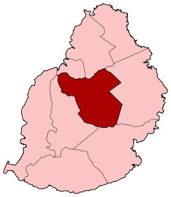
Map of Mauritius island with Moka District highlighted |
| Country |
 Mauritius Mauritius |
|---|
| Government[1] |
|---|
| • Type |
District Council |
|---|
| • Chairman |
Mr. Golam Chandradath |
|---|
| • Vice Chairman |
Heerooa Ramnarain |
|---|
| Area |
|---|
| • Total |
230.5 km2 (89.0 sq mi) |
|---|
| Population (2012)[2] |
|---|
| • Total |
81,820 |
|---|
| • Rank |
7th in Mauritius |
|---|
| • Density |
350/km2 (920/sq mi) |
|---|
| Time zone |
MUT (UTC+4) |
|---|
| ISO 3166 code |
MU-MO (Moka) |
|---|
Moka is a district of Mauritius, situated in the central plateau of the island. The district has an area of 230.5 km2 and the population estimate was at 81,820 as of 31 December 2012.[2]
History
Places of interest
Places
The Moka District include different regions; however, some regions are further divided into different suburbs.[2][3]
- Camp Thorel
- Curepipe (West - Ward 2)
- Dagotière
- Dubreuil (East in Flacq district)
- Espèrance
- L'Avenir
- La Laura-Malenga
- Melrose
- Moka (West in Plaines Wilhems district)
- Montagne-Blanche (East in Flacq district)
|
- Médine Camp de Masque (East in Flacq district)
- Nouvelle Decouverte
- Providence
- Quartier-Militaire
- Ripailles
- Saint Julien, Haut de Flacq (East in Flacq district)
- Saint Julien d'Hotman (East in Flacq district)
- Saint-Pierre, Mauritius
- Vacoas-Phoenix (West - Ward 4)
- Verdun
|
See also
References
| |
Port Louis |
Pamplemousses |
Flacq |
 |
| Plaines Wilhems |
 |
Flacq |
|
|
 |
| Plaines Wilhems |
Grand Port |
|
Coordinates: 20°15′S 57°34′E / 20.250°S 57.567°E / -20.250; 57.567


