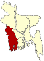
Mohammadpur Upazila
| Mohammadpur মোহাম্মদপুর (মাগুরা) | |
|---|---|
| Upazila | |
 Mohammadpur | |
| Coordinates: 23°24.3′N 89°36.3′E / 23.4050°N 89.6050°ECoordinates: 23°24.3′N 89°36.3′E / 23.4050°N 89.6050°E | |
| Country |
|
| Division | Khulna Division |
| District | Magura District |
| Area | |
| • Total | 234.29 km2 (90.46 sq mi) |
| Population (1992) | |
| • Total | 160,340 |
| • Density | 684/km2 (1,770/sq mi) |
| Time zone | BST (UTC+6) |
| Website | Official Map of Mohammadpur |
Mohammadpur (Bengali: মোহাম্মদপুর (মাগুরা)) is an Upazila of Magura District in the Division of Khulna, Bangladesh.
Geography
Mohammadpur is located at 23°24′15″N 89°36′15″E / 23.4042°N 89.6042°E . It has 28158 units of house hold and total area 234.29 km². River Naboganga flows through the Upazila. It is reported in the newspaper that coal has been found in the river bed after extractiong sand.
Demographics
As of the 1991 Bangladesh census, Mohammadpur has a population of 160340. Males constitute 50.58% of the population, and females 49.42%. This Upazila's eighteen up population is 76748. Mohammadpur has an average literacy rate of 25.8% (7+ years), and the national average of 32.4% literate.[1] Mohammadpur stand's near the bank of Modhumoti river. The modhumoti river dived Mohammadpur from Dhaka division. The river has a great effect on the climate and the life style of Mohammadpur Upozila.
Administrative
Mohammadpur has 8 Unions/Wards, 131 Mauzas/Mahallas, and 182 villages.
See also
- Upazilas of Bangladesh
- Districts of Bangladesh
- Divisions of Bangladesh
- Mithun Roy Chowdhury
References
- ↑ "Population Census Wing, BBS.". Archived from the original on 2005-03-27. Retrieved November 10, 2006.
