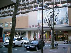
Minami-Fukuoka Station
From Wikipedia, the free encyclopedia
Minami-Fukuoka Station 南福岡駅 | |
 | |
|---|---|
| Location | |
| Prefecture | Fukuoka (See other stations in Fukuoka) |
| City | Fukuoka |
| Ward | Hakata |
| History | |
| Year opened | 1890 |
| Former name | Zasshonokuma Station |
| Present name since | 1966 |
| Rail services | |
| Operator(s) | Kyushu Railway Company |
| Line(s) | Kagoshima Main Line |
| Statistics | 8,198[citation needed] passengers/day 2007 |
Minami-Fukuoka Station (南福岡駅) is a train station operated by Kyushu Railway Company on the Kagoshima Main Line in Hakata-ku, Fukuoka in Japan.
Platforms
| 1 | ■Kagoshima Main Line | for Futsukaichi, Kurume and Ōmuta |
| 2 | ■Kagoshima Main Line | for Futsukaichi, Kurume and Ōmuta |
| 3 | ■Kagoshima Main Line | for Hakata, Akama and Kokura |
| 4 | ■Kagoshima Main Line | for Hakata, Akama and Kokura |
| 5 | ■Kagoshima Main Line | for Hakata, Akama and Kokura |
Adjacent stations
| « | Service | » | ||
|---|---|---|---|---|
| Kagoshima Main Line | ||||
| Sasabaru | - | Kasuga | ||
Vicinity
- Lawson Convenience Store
- Motomachi Shopping Street
- JR Kyūshū train yard
- Zasshonokuma : Tenjin Ōmuta Line
- NTT Building
- Japan Ground Self-Defense Force, Camp Fukuoka (4th Division Headquarter)
- Nakoku no okarekishi Park
- Nishitetsu Bus station
History
The station was originally named Zasshonokuma Station (雑餉隈駅). However, many users complained because a nearby station on the Tenjin Ōmuta Line bore the same name.
- January 20, 1890: Station opens as "Zasshonokuma station".
- October 15, 1919: Double-track line between Hakata and Futsukaichi opens.
- October 14, 1960: Minami-Fukuoka train yard opens.
- June 1, 1961: Line is electrified between Kurume and Mojikō.
- November 1, 1966: Station renamed Minami-Fukuoka Station.
- April 1, 1987: Privatization of Japanese National Railways (JNR). Line resumed under Kyushu Railway Company.
- 1994: Station burned down in arson attack.
- July 1999: Station rebuilt with automatic ticket gates.
- 2006: Elevators added to platforms.
References
Coordinates: 33°32′33″N 130°27′33″E / 33.5424°N 130.4593°E
This article is issued from Wikipedia. The text is available under the Creative Commons Attribution/Share Alike; additional terms may apply for the media files.