Metropolitan Region Scheme

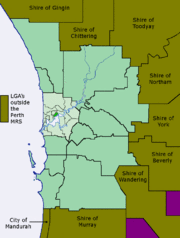
The Metropolitan Region Scheme (MRS) is the legal land plan covering urban planning throughout the Perth Metropolitan Region. It classifies land into broad zones and reservations and is administered by the Western Australian Planning Commission.
The scheme defines the future use of land, dividing it into broad zones and reservations. It requires local government town planning schemes to provide detailed plans for their part of the region. Local government schemes must be consistent with the MRS.
The MRS derived from Hepburn and Stephenson's 1955 Plan for the Metropolitan Region, Perth and Fremantle and has been in operation since 1963. Hepburn and Stephenson were commissioned by the Government of Western Australia to develop the plan in 1953. The overall structure was updated and extended in the Corridor Plan of 1970 and the Metroplan of 1990.
References
- "Schemes". Planning Western Australia. Retrieved 2009-10-08.
- "Scheme text". Planning Western Australia. Retrieved 2009-10-08.
- "Honorary Degree Citation, Gordon Stephenson, CBE". Murdoch University. Retrieved 2007-02-13.
- "Statement by the Minister for Planning". Hansard, Parliament of Western Australia. 8 April 1997. Retrieved 2007-02-13.
- "Background Paper 4". Planning Western Australia. Retrieved 2007-08-16.
Coordinates: 31°57′S 115°51′E / 31.950°S 115.850°E