Medjerda River
| Medjerda (واد مجردا) | |
|---|---|
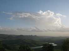
.jpg) The Medjerda River | |
| Origin | Tell Atlas, Algeria |
| Mouth | Gulf of Tunis, Mediterranean Sea |
| Basin countries | Algeria and Tunisia |
| Length | 460 kilometres (290 mi) |
| Source elevation | 0 m |
| Avg. discharge | 29 m³/s |
| Basin area | 22,000 km² |
The Mejerda River (Arabic: واد مجردا) is a river in North Africa flowing from northeast Algeria through Tunisia before emptying in the Gulf of Tunis and Lake of Tunis. With a length of 450 km it is the longest river of Tunisia. It is also known as the wādi Majardah, Wadi Mejerha and Oued Majardah, and it was known as Bagrada in ancient times.[1]
Course
It originates in the Tell Atlas, part of the Atlas Mountains, in northeastern Algeria and then flows eastwards to Tunisia, then entering the Gulf of Utica of the Mediterranean Sea. Its course has a length of 460 kilometres (290 mi). It is the most important and longest rivers in Tunisia and is dammed in several locations, being a major supplier of water to the country's wheat crops.
Gulf of Utica was formed during the postglacial transgression about 6,000 years ago. Over time, fluvial deposits from the Mejerda gradually filled up the northern part of the gulf. The succession of events during historical times has been inferred from ancient documents and archaeological evidence. Besides morphological ground observations, aerial and satellite photographs have been used to analyze how the landscape has evolved over the past 3,000 years. The gulf's southern part was filled up in late ancient times. The sea gradually withdrew from the northern part during the Middle Ages and modern times. The Ghar el Melh lagoon is the last vestige of what used to be the Utica gulf.
Following the last big flood in 1973, the Mejerda shifted, once again, its course. It now flows through a canal originally dug to evacuate the overflow of flood waters.[2]
History
Historically the Medjerda is Tunisia's crucial waterway providing water to the country supply facilities, it is also vital to the people living near the river. Water from Mejerda is used to irrigation and is pivotal to the region's agriculture.
A very strategic river in North Africa, it was fought over and settled many times in history by the Berbers, Phoenicians, Punics, Romans, Vandals, Byzantines, Arabs, and the Ottomans. Several major cities, such as Utica, Carthage, and eventually Tunis were founded on or in close proximity to it.
See also
References
| |||||
Coordinates: 37°07′N 10°13′E / 37.117°N 10.217°E