McKenzie River (Oregon)
| McKenzie River | |
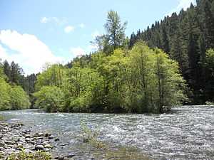
 An island in the upper McKenzie | |
| Country | United States |
|---|---|
| State | Oregon |
| Counties | Lane, Linn |
| Source | Clear Lake |
| - location | Cascade Range, Linn County |
| - elevation | 3,570 ft (1,088 m) [1] |
| - coordinates | 44°21′37″N 121°59′39″W / 44.36028°N 121.99417°W [2] |
| Mouth | Willamette River |
| - location | Lane County |
| - elevation | 371 ft (113 m) [2] |
| - coordinates | 44°7′32″N 123°6′20″W / 44.12556°N 123.10556°W [2] |
| Length | 90 mi (145 km) [3][4] |
| Basin | 1,300 sq mi (3,367 km2) [3][4] |
| Discharge | for river mile 27.7 near Walterville |
| - average | 2,897 cu ft/s (82 m3/s) [5] |
| - max | 56,100 cu ft/s (1,589 m3/s) |
| - min | 420 cu ft/s (12 m3/s) |
 Location of the mouth of the McKenzie River in Oregon
| |
| Wikimedia Commons: McKenzie River | |
The McKenzie River is a 90-mile (145 km) tributary of the Willamette River in western Oregon in the United States. It drains part of the Cascade Range east of Eugene and flows into the southernmost end of the Willamette Valley. It is named for Donald Mackenzie, a Scottish Canadian fur trader who explored parts of the Pacific Northwest for the Pacific Fur Company.[6][7] In the 21st century, there are six large dams on the McKenzie and its tributaries.[8]
Course
The McKenzie River originates as the outflow of Clear Lake in the high Cascades of eastern Linn County in the Willamette National Forest. Clear Lake is fed by Ikenick Creek and Fish Lake Creek, the latter of which flows from Fish Lake (a few miles north of Clear Lake, in Marion County). Fish Lake's main tributary is Hackieman Creek, which drains the north side of Browder Ridge east of Tombstone Pass. U.S. Route 20 crosses the pass and follows Hackieman Creek. The McKenzie River flows south from Clear Lake, paralleled by Oregon Route 126, and goes over Sahalie and Koosah falls. It enters Lane County and flows west past the community of McKenzie Bridge. It receives the South Fork McKenzie River about 3 miles (5 km) east of Blue River. The South Fork rises near the Pacific Crest Trail in the Three Sisters Wilderness and flows north-northwest for about 30 miles (48 km) through Cougar Reservoir and Cougar Dam.[9]
After the South Fork confluence, the main stem McKenzie River flows west through a narrow valley in the mountains, past Vida to Leaburg and Walterville. The McKenzie valley widens as the river continues west, and as it emerges from the mountains it passes along the north side of Springfield into a broad floodplain and joins the Willamette from the east 5 miles (8 km) north of Eugene.[4][9]
Watershed

The McKenzie River drains a region of 1,300 square miles (3,400 km2) and is one of the primary tributaries of the Willamette River. Elevations within the region range from 10,358 feet (3,157 m) at the summit of the South Sister to 375 feet (114 m) at the McKenzie's mouth on the Willamette River north of Eugene. The upper basin, in the high Cascades, consists of granular, permeable igneous rocks that are geologically young, while most of the middle and lower McKenzie valley in the Western Cascades is made up of the remnants of older, more weathered volcanic rocks. The McKenzie basin is bordered by the watersheds of the Calapooia, North Santiam, and South Santiam rivers to the north; the Middle Fork Willamette River to the south; and the Deschutes River to the east.[4]
The watershed is lightly populated; about 70 percent of it is public land managed by the U.S. Government, of which about 39 percent is the Three Sisters Wilderness. Over 96 percent of the basin is forested and just below 4 percent is devoted to agricultural use—mainly on the lower floodplain—and the remainder is residential or industrial. The river is the sole tap water source for the cities of Eugene and Springfield, fulfilling the water needs of about 200,000 people.[8]
Precipitation in the basin varies greatly with elevation; about 40 inches (1,000 mm) falls annually in the driest part of the basin, the Willamette Valley, whereas the Three Sisters in the high Cascades can receive 125 inches (3,200 mm) each year. Above 4,000 feet (1,200 m), about 35 percent of precipitation falls as snow, and at 7,000 feet (2,100 m) and higher, over three quarters of precipitation is snowfall. At these elevations, snowmelt beginning in the spring season brings cold water out of springs, increasing the McKenzie's discharge and maintaining low water temperatures in the river and its tributaries. But on the lower McKenzie, heavy precipitation leads to ample water erosion of sediment into the river, because the rocks of the Western Cascades are less permeable than those in the upper basin.[4]
Engineering
There are three dams and reservoirs on the main stem of the McKenzie; they are the Carmen, the Trail Bridge, and the Leaburg.[10] The Carmen Diversion Dam is the uppermost dam on the river, located less than 2 miles (3.2 km) south of Clear Lake.[11] Some water from this dam's impoundment, Carmen Reservoir, is diverted southwest via artificial tunnel to Smith Reservoir on the Smith River. The McKenzie, meanwhile, flows out of the east end of Carmen Reservoir and follows Route 126. Via both the Smith River and another tunnel, water in Smith Reservoir moves south to the Carmen Power Plant, into Trail Bridge Reservoir—which the free-flowing McKenzie joins—and through power-producing Trail Bridge Dam. The system is called the Carmen–Smith Hydroelectric Project, and it has been used by the Eugene Water & Electric Board (EWEB) since 1963 to generate electricity for its customers.[11][12][13]
Communities

The eastern portion of Oregon Route 126 passes through the valley of the McKenzie River, closely following the river for much of its route. The 60-mile (97 km) stretch of the river from the edge of the Springfield metro area east to the Cascades is known as the McKenzie Valley.[14] The following communities, listed west to east, are in the valley: Cedar Flat, Walterville, Deerhorn, Leaburg, Vida, Nimrod, Finn Rock, Blue River, Rainbow, McKenzie Bridge, and Belknap Springs.[10]
History
For about 8,000 years, the McKenzie River has been home to local Native American peoples of the region. In more recent history, the area has been populated by the Kalapuya and Molala peoples, who spent their summers in the high Cascades and their winters in the lower valley. This way of life continued until the mid-19th century, when many of native locals were relocated to reservations.[10]
The first recorded exploration occurred in the spring of 1812 by the Pacific Fur Company, as part of a larger exploration led by Donald Mackenzie. The company had, in 1811, established a post at Fort Astoria at the mouth of the Columbia River as part of the Astor Expedition. Mackenzie, the following spring, formed an exploration party and explored the Willamette River. The party named the north fork of the Willamette after Mackenzie.[10][15] However, much of the river was largely unvisited by white settlers and explorers until October 1853, when a group of Oregon Trail settlers became lost trying to cross the Cascades into the Willamette Valley via the Elliott Cutoff.[10]
Major crossing along the McKenzie River started in 1910 with the first automobile crossing over the McKenzie Pass. However, crossing along the river was limited to summer due to winter conditions closing the pass. Year-round travel was not possible until 1960 with the completion of the Santiam Pass.[10]
Flora and fauna

Fish in the McKenzie River and some of its tributaries include spring Chinook salmon, mountain whitefish, and bull and rainbow trout. Dippers, mergansers, Bald Eagles, Ospreys, and various ducks feed on the fish.[16] The endangered Northern Spotted Owl inhabits dense forest on the west side of the upper McKenzie basin in Linn County.[12]
Forests of Douglas fir, western hemlock, and western red cedar are common within the watershed.[10][12][17]
Recreation
See also

References
- ↑ Derived from Google Earth search using Geographic Names Information Service (GNIS) source coordinates.
- ↑ 2.0 2.1 2.2 "McKenzie River". Geographic Names Information System (GNIS). United States Geological Survey. November 28, 1980. Retrieved August 7, 2010.
- ↑ 3.0 3.1 "Watershed Facts". McKenzie Watershed Council. Retrieved September 29, 2009.
- ↑ 4.0 4.1 4.2 4.3 4.4 "Scientific Investigations Report 2010–5016: Development of an Environmental Flow Framework for the McKenzie River Basin, Oregon". U.S. Geological Survey. February 8, 2010. Retrieved January 30, 2013.
- ↑ "Water Resources Data for Oregon, Water Year 2005; McKenzie River Basin including and below the Blue River" (PDF). United States Geological Survey. Retrieved September 29, 2009.
- ↑ McArthur, Lewis (2003). Oregon Geographic Names. Portland: Oregon Historical Society Press. pp. 628–629. ISBN 0-87595-277-1.
- ↑ Mackenzie, Cecil Walter (1937). Donald Mackenzie, "King of the Northwest". Los Angeles, California: I. Deach, Jr. p. 91. OCLC 3023859.
- ↑ 8.0 8.1 "About the McKenzie Watershed". McKenzie Watershed Council. Retrieved January 9, 2010.
- ↑ 9.0 9.1 General course info from USGS topographic maps accessed via the "GNIS in Google Map" feature of the USGS Geographic Names Information System website; and Oregon Road & Recreation Atlas (Second ed.). Benchmark Maps. 2002. ISBN 0-929591-50-X.
- ↑ 10.0 10.1 10.2 10.3 10.4 10.5 10.6 Williams, Gerald W. "McKenzie River". The Oregon Encyclopedia. Portland State University. Retrieved January 11, 2011.
- ↑ 11.0 11.1 "Smith Reservoir". Google Maps. Retrieved July 7, 2013.
- ↑ 12.0 12.1 12.2 "Smith Reservoir (Linn County)". Atlas of Oregon Lakes. Portland State University. Retrieved July 7, 2013.
- ↑ "Carmen Smith Hydroelectric Project". Eugene Water & Electric Board. Retrieved July 7, 2013.
- ↑ "Oregon's McKenzie River Communities". McKenzie River Reflections. Archived from the original on February 5, 2012.
- ↑ Munford, Kenneth. "The McKenzie River trails". Benton County Historical Society & Museum. Retrieved January 11, 2011.
- ↑ "McKenzie River Area". U.S. Forest Service. Retrieved May 12, 2013.
- ↑ "McKenzie Bridge Campground". U.S. Forest Service. Retrieved July 7, 2013.
External links
-
 Media related to McKenzie River (Oregon) at Wikimedia Commons
 - McKenzie Watershed Council