Mawei District
| Mawei 马尾 | |
|---|---|
| District | |
| 马尾区 | |
 | |
 Mawei | |
| Coordinates: 26°00′41″N 119°27′25″E / 26.01139°N 119.45694°ECoordinates: 26°00′41″N 119°27′25″E / 26.01139°N 119.45694°E | |
| Country | People's Republic of China |
| Province | Fujian |
| Prefecture-level city | Fuzhou |
| Time zone | China Standard (UTC+8) |
Mawei (simplified Chinese: 马尾; traditional Chinese: 馬尾; pinyin: Mǎwěi; Foochow Romanized: Mā-muōi) is a district of Fuzhou, Fujian province, People's Republic of China.
Mawei District is located on the left (northern) shore of the Min River, between Fuzhou's urban core and the coast of the Taiwan Strait. The district also includes Langqi Island formed by the two main branches of the Min River as it flows into the sea.
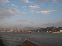
Mawei District is famous for its historical Mawei Navy Yard, with a modern shipyard operating on the site.
The Min River separates Mawei District from Changle City on the river's southern bank. Qingzhou Bridge spans the river, connecting Mawei's main urban center (the Mawei Town / Luoxing Subdistrict area) with Changle.
Administrative division

Subdistricts:
- Wuhang Subdistrict (吴航街道), Hangcheng Subdistrict (航城街道), Zhanggang Subdistrict (漳港街道), Yingqian Subdistrict (营前街道)
Towns:
- Shoudian (首占镇), Yutian (玉田镇), Guhuai (古槐镇), Jiangtian (江田镇), Songxia (松下镇), Jinfeng (金峰镇), Heshang (鹤上镇), Hunan (湖南镇), Wenling (文岭镇), Meihua (梅花镇), Zhangtou (潭头镇), Wenwusha (文武砂镇)
Townships:
- Luolian Township (罗联乡), Houyu Township (猴屿乡)
| |||||||||||||||||||||||||||||||||||||||