Maurice River
| Maurice River | |
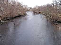
 The Maurice River in Millville in 2006 | |
| Country | United States |
|---|---|
| State | New Jersey |
| Counties | Salem and Cumberland |
| Tributaries | |
| - left | Burnt Mill Branch, Blackwater Branch, Little Robin Branch, Parvin Branch, Manantico Creek, Manumuskin River, Muskee Creek, Little Mill Creek |
| - right | Green Branch, Muddy Run, Mill Creek, White Marsh Run, Buckshutem Creek, Steep Run, Peterson Run, Sheppards Branch |
| Cities | Vineland, Millville |
| Coordinates | 39°12′49″N 75°2′39″W / 39.21361°N 75.04417°W |
| Source | |
| - location | Pittsgrove Township |
| Source confluence | Still Run and Scotland Run |
| - coordinates | 39°33′00″N 75°04′16″W / 39.5501153°N 75.0710102°W |
| Mouth | Delaware Bay |
| Length | 50 mi (80 km) approx. |
| Basin | 386 sq mi (1,000 km2) approx. |
| Discharge | for Norma (Pittsgrove Township) |
| - average | 117 cu ft/s (3 m3/s) [1] |
| - max | 922 cu ft/s (26 m3/s) 1940 |
| - min | 24 cu ft/s (1 m3/s) 1966 |

The Maurice River is a tributary of Delaware Bay in Salem County and Cumberland County, New Jersey in the United States.
Watershed and course
The Maurice River, pronounced "Morris," is approximately 50 mi (80 km) long with a drainage area of 386 sq mi (1,000 km2).[2] It is the second longest and largest tributary to Delaware Bay.[citation needed] Its watershed includes an extensive southern portion of the coastal forested wetlands known as the Pine Barrens. Its mouth on Delaware Bay is surrounded by extensive salt marshes and has provided an historically important oystering ground.
It is born at the confluence of Still Run and Scotland Run, beneath the waters of Willow Grove Lake in Pittsgrove, Salem County and flows generally south-southeast, passing 2 miles (3 km) west of Vineland. At Millville it is impounded to form the Union Lake reservoir, approximately 3 miles (5 km) long. South of Millville it becomes navigable, forming a 10-mile (16 km) estuary that empties into Maurice River Cove on Delaware Bay. The estuary is joined from the northeast by Manantico Creek, the Manumuskin River, and Muskee Creek.
Water quality and stewardship
The river is considered especially pristine for the region, forming a critical ecological link between the Pine Barrens and the Delaware Bay systems. It is the location of one of the only stands of wild rice in New Jersey, and provides habitat for 53 percent of the species in New Jersey designated as endangered. In 1993, Congress designated 28.9 miles (46.5 km) of the river and its tributaries as the Maurice National Scenic and Recreational River, as part of the National Wild and Scenic Rivers program.
A local nonprofit organization, Citizens United to Protect the Maurice River and Its Tributaries, Inc., is a regional watershed organization that focuses its work on the Maurice River watershed, from Willow Grove Lake southward. The South Jersey Land and Water Trust focuses on the northern portion of the watershed, from Willow Grove Lake northward.
Tributaries
See also
- List of New Jersey rivers
References
- ↑ U.S. Geological Survey (2013-09-04). "Current Conditions for USGS 01411500 Maurice River at Norma NJ."
- ↑ New Jersey Dept. of Environmental Protection, Trenton, NJ. (2012). "Watershed Management Area 17: Maurice, Salem, Cohansey."
External links
- Wild and Scenic Maurice River
- National Park Service: Maurice Wild and Scenic River
- U.S. Geological Survey: NJ stream gaging stations
- U.S. Geological Survey Geographic Names Information System: Maurice River