Maud Island
| Maori: Te Hoiere | |
|---|---|
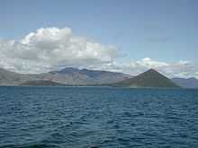
 Maud Island viewed from northeast | |
| Geography | |
| Location | Pelorus Sound |
| Coordinates | 41°02′S 173°53′E / 41.033°S 173.883°E |
| Length | 3.5 km (2.17 mi) |
| Highest elevation | 368 m (1,207 ft) |
| Country | |
| Demographics | |
| Population | 0 |
Maud Island, originally called Te Hoiere in the Māori language, is the second-largest island in the Marlborough Sounds on the northern tip of the South Island of New Zealand, with a total area of 320 ha (790 acres).
Coordinates: 41°02′S 173°53′E / 41.033°S 173.883°E
Fauna
Maud Island is an important nature reserve (officially a Scientific Reserve as defined under New Zealand's Reserves Act) to which only scientists and conservationists have access. Visitors need a special permit issued by the New Zealand Department of Conservation. Thanks to the efforts of conservationist Don Merton the Kakapo was introduced onto the predator-free island in 1974. Additional Kakapo were subsequently translocated onto other Islands like Codfish Island, Anchor Island and Little Barrier Island. But after only one breeding attempt by pair Flossie and Richard Henry in 1998 where three chickens were born, Maud Island's Kakapo population was translocated to more forested islands. The takahe was also introduced there in 1985. Another rare species is the Maud Island Frog (Leiopelma pakeka), which was split from the Hamilton's Frog (Leiopelma hamiltoni) in 1998 and is now seen as its own species.