Matsudo Station
Matsudo Station 松戸駅 | |
 | |
|---|---|
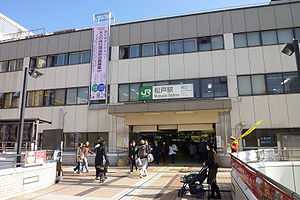
| West Exit, Matsudo Station | |
| Location | |
| Prefecture | Chiba (See other stations in Chiba) |
| City | Matsudo |
| Neighborhood etc. | 1181 Matsudo |
| Postal code | 271-0092 |
| (in Japanese) | 千葉県松戸市松戸1181 |
| History | |
| Year opened | 1896 |
| Rail services | |
| Operator(s) | JR East, Shin-Keisei Electric Railway |
| Line(s) | Jōban Line Shin-Keisei Line |
| Statistics | 100,591 (JR East) 110,072 (Shin Keisei) passengers/day (FY2009) |
Matsudo Station (松戸駅 Matsudo-eki) is a railway station in Matsudo, Chiba, Japan, operated by East Japan Railway Company (JR East) and Shin-Keisei Electric Railway.
Lines
Matsudo Station is served by the Jōban Line from Ueno in Tokyo, and is also the terminus for the Shin-Keisei Line.
Station layout
Matsudo Station has four island platforms serving eight tracks.
Platforms
| 1 | ■Jōban Line (Rapid) | for Kashiwa, Toride, Narita, Tsuchiura, Mito, and Iwaki |
| 2 | ■Jōban Line (Rapid) | for Kashiwa, Toride, Narita, Tsuchiura, Mito, and Katsuta for Kita-Senju, Nippori, and Ueno |
| 3 | ■Jōban Line (Rapid) | for Kita-Senju, Nippori, and Ueno |
| 4 | ■Jōban Line (Local) | for Shin-Matsudo, Abiko, and Toride |
| 5 | ■Jōban Line (Local) | for Shin-Matsudo, Abiko, and Toride for Ayase, Kita-Senju |
| 6 | ■Jōban Line (Local) | for Ayase, Kita-Senju |
| 7, 8 | ■Shin-Keisei Line | for Yabashira, Shin-Kamagaya, Kita-Narashino, Keisei-Tsudanuma (via Keisei Chiba Line) |
Adjacent stations
| « | Service | » | ||
|---|---|---|---|---|
| Jōban Line (Rapid) | ||||
| Nippori | Special Rapid | Kashiwa | ||
| Kita-Senju | Rapid | Kashiwa | ||
| Jōban Line (Local) | ||||
| Kanamachi | Local | Kita-Matsudo | ||
| Shin-Keisei Line | ||||
| Terminus | Kamihongō | |||
History
Matsudo Station opened on December 25, 1896 as a station on the Nippon Railway Tsuchiura Line. It was nationalised on November 1, 1906, becoming part of the Japanese Government Railways (JGR) and the line name changed on October 12, 1909 to the Jōban Line. JGR became Japanese National Railways (JNR) after World War II. The Shin-Keisei Line began operations from April 21, 1955. The station was absorbed into the JR East network upon the privatization of JNR on April 1, 1987.
Surrounding area
- Seitoku University
- Tojogaoka Historic Park
- Matsudo City Hall
External links
| Wikimedia Commons has media related to Matsudo Station. |
- JR East Station information (Japanese)
- Shin Keisei Station Information (Japanese)
| |||||
| |||||
| ||||||||
Coordinates: 35°47′03″N 139°54′03″E / 35.7843°N 139.9007°E