Mathraki
From Wikipedia, the free encyclopedia
| Mathraki | |
|---|---|
| Location | |
 Mathraki | |
| Coordinates | 39°46′N 19°31′E / 39.767°N 19.517°ECoordinates: 39°46′N 19°31′E / 39.767°N 19.517°E |
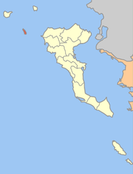
Location within the regional unit  | |
| Government | |
| Country: | Greece |
| Administrative region: | Ionian Islands |
| Regional unit: | Corfu |
| Municipality: | Corfu |
| Population statistics (as of 2001)[1] | |
| Municipal unit | |
| - Population: | 297 |
| - Area: | 2.9 km2 (1 sq mi) |
| - Density: | 102 /km2 (265 /sq mi) |
| Other | |
| Time zone: | EET/EEST (UTC+2/3) |
| Elevation: | 152 m (499 ft) |
| Postal code: | 491 00 |
| Telephone: | 26630 |
| Auto: | ΚΥ |
| Website | |
| mathraki.corfumail.gr | |
Mathraki (Greek: Μαθράκι, older form: Μαθράκιον) is an island and a former community of the Ionian Islands, Greece. Since the 2011 local government reform it is part of the municipality Corfu, of which it is a municipal unit.[2] Population 297 (2001). Mathraki is a 45 minute boat ride off the coast of Corfu (4 NM from Cape Arilas). It has three restaurants that double as general stores, villas and "rooms to let". Mathraki is a quiet island that manages to stay clear of tourists except for the occasional hikers that brave the rocky coastline. The municipal unit includes the three nearby islets Diakopo, Diaplo and Tracheia.
References
- ↑ De Facto Population of Greece Population and Housing Census of March 18th, 2001 (PDF 793 KB). National Statistical Service of Greece. 2003.
- ↑ Kallikratis law Greece Ministry of Interior (Greek)
External links
- Official site from Local Authority Official site from Mathraki Local Authority (Languages Greek-English-Italian
- Official site from Prefecture of Corfu Official site from Prefecture of Corfu (multi language)
| ||||||||
| |||||||||||||||||||||||||||||||||||||||||||||||
This article is issued from Wikipedia. The text is available under the Creative Commons Attribution/Share Alike; additional terms may apply for the media files.