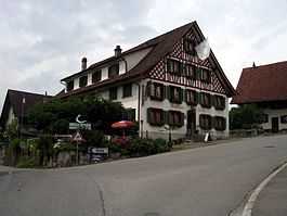
Maschwanden
| Maschwanden | ||||||||||
|---|---|---|---|---|---|---|---|---|---|---|
 | ||||||||||
| Population | 641 (Dec 2012)[1] | |||||||||
| - Density | 137 /km2 (355 /sq mi) | |||||||||
| Area | 4.69 km2 (1.81 sq mi)[2] | |||||||||
| Elevation | 398 m (1,306 ft) | |||||||||
| Postal code | 8933 | |||||||||
| SFOS number | 0008 | |||||||||
| Surrounded by | Cham (ZG), Hünenberg (ZG), Knonau, Mettmenstetten, Obfelden | |||||||||
| Website | www.maschwanden.ch SFSO statistics | |||||||||
 Maschwanden | ||||||||||
| Location of Maschwanden
 | ||||||||||
Maschwanden is a village in the district of Affoltern in the canton of Zürich in Switzerland.
History
Maschwanden is first mentioned in 1189 as Maswondon.[3] The Baron of Eschenbach owned a castle and the village, near the current municipality, at that time. However, in 1308 Walter von Eschenbach was present at the regicide of King Albert I of Germany near Windisch. In response to the murder, in 1309 the castle and village were both destroyed and never rebuilt. The ruins were located on a hill south-west of the modern village, which mostly consisted of gravel and was carried off during the 19th and 20th century.[4]
Geography
Maschwanden has an area of 4.7 km2 (1.8 sq mi). Of this area, 61.5% is used for agricultural purposes, while 24.1% is forested. Of the rest of the land, 8.3% is settled (buildings or roads) and the remainder (6%) is non-productive (rivers, glaciers or mountains).[5]
The municipality is located on the east banks of the Reuss River near the confluence of the Lorze River into the Reuss.
Demographics
Maschwanden has a population (as of 31 December 2012) of 641.[1] As of 2007, 4.5% of the population was made up of foreign nationals. Over the last 10 years the population has grown at a rate of 12.8%. Most of the population (as of 2000) speaks German (97.8%), with Portuguese being second most common ( 0.7%) and Italian being third ( 0.5%).
In the 2007 election the most popular party was the SVP which received 45% of the vote. The next three most popular parties were the SPS (21.4%), the CSP (14.6%) and the Green Party (7.2%).
The age distribution of the population (as of 2000) is children and teenagers (0–19 years old) make up 27.5% of the population, while adults (20–64 years old) make up 59.3% and seniors (over 64 years old) make up 13.2%. The entire Swiss population is generally well educated. In Maschwanden about 81.4% of the population (between age 25-64) have completed either non-mandatory upper secondary education or additional higher education (either university or a Fachhochschule).
Maschwanden has an unemployment rate of 0.36%. As of 2005, there were 61 people employed in the primary economic sector and about 24 businesses involved in this sector. 12 people are employed in the secondary sector and there are 4 businesses in this sector. 49 people are employed in the tertiary sector, with 19 businesses in this sector.[5] The historical population is given in the following table:[3]
| year | population |
|---|---|
| 1470 | c. 120 |
| 1634 | 339 |
| 1786 | 507 |
| 1850 | 578 |
| 1900 | 493 |
| 1920 | 424 |
| 1950 | 470 |
| 1970 | 400 |
| 2000 | 553 |
References
- ↑ 1.0 1.1 Canton of Zurich Statistical Office (German) accessed 1 May 2013
- ↑ Arealstatistik Standard - Gemeindedaten nach 4 Hauptbereichen
- ↑ 3.0 3.1 Maschwanden in German, French and Italian in the online Historical Dictionary of Switzerland.
- ↑ Maschwanden website-History (German) accessed 26 May 2010
- ↑ 5.0 5.1 Swiss Federal Statistical Office accessed 24-Jul-2009
External links
| Wikimedia Commons has media related to Maschwanden. |
- Official website (German)
- Maschwanden in German, French and Italian in the online Historical Dictionary of Switzerland.
| |||||||||||
