Marston Bigot
| Marston Bigot | |
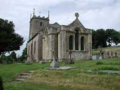
 Church of St Leonard, Marston Bigot |
|
 Marston Bigot | |
| OS grid reference | ST758448 |
|---|---|
| Civil parish | Trudoxhill |
| District | Mendip |
| Shire county | Somerset |
| Region | South West |
| Country | England |
| Sovereign state | United Kingdom |
| Post town | FROME |
| Postcode district | BA11 |
| Police | Avon and Somerset |
| Fire | Devon and Somerset |
| Ambulance | South Western |
| EU Parliament | South West England |
| UK Parliament | Somerton and Frome |
Marston Bigot is a small village near Nunney and 3 miles (5 km) south of Frome in Somerset, England.
History
Marston Bigot was listed as "Mersitone-tora" in the Doomesday Book, which gave the name of the then Saxon landowner as Robert Arundel. It became known as Marston Bigot some time after it was given by William the Conqueror to Roger de Bigod,[1] which later became the Bigott family.[2] The manor of Marston Bigot was held by the Crown after the execution of Lord Charles Stourton, 8th Baron Stourton in 1557. It was sold by Elizabeth I in 1596 to William Brown and James Orenge, or Orange.[3]
The parish was part of the hundred of Frome.[4]
Nearby is Marston Moat the site of a fortified manor house.
Marston Bigot Park
Marston Bigot Park encompasses approximately 222 hectares (2,220,000 m2) and includes Marston House, Marston Pond and the remains of the medieval shrunken village of Lower Marston.[5]
House

The earliest description of Marston House is contained in a letter from Richard Boyle, 1st Earl of Cork, in 1641, when he purchased the Manor from Sir John Hippisley. In 1714, Marston was inherited by Charles Boyle, 4th Earl of Orrery, who rebuilt it. The house later passed to John Boyle, 5th Earl of Cork, and successive generations, who each left their mark on the house and grounds, including Edmund Boyle, 7th Earl of Cork who added added Marston Pond, a boathouse, and three gate lodges. However late in the 19th century the house fell into disrepair and it was sold in 1905 to the Bonham-Christie family.[3]
Marston House and its grounds were used by the US Army during World War II, and were finally rescued from dereliction in 1984 by John and Angela Yeoman of Foster Yeoman Ltd, and used as the company headquarters.[3] Foster Yeoman put the house on the market in 2012 at a price of £6 million.[6]
The house is a Grade II* listed building. It is built of squared and coursed Doulting stone with a slate roof and balustraded parapet, located on a 180 metres (591 ft) long terrace with stone urns. The house is 130 metres (427 ft) long but generally only 20 metres (66 ft) deep, therefore presenting a massive facade when viewed from the park. In the three-storey central block of this front are four Ionic columns, which were built by Sir Jeffry Wyattville around 1817, with two-storey wings on either side, which were added in 1776 by Samuel Wyatt.[7]
Gardens
The garden at Marston House is listed Grade II in the Register of Parks and Gardens of Special Historic Interest in England.
The gardens were laid out by Stephen Switzer between 1724 and 1745. They cover an approximately rectangular area of approximately 8.5 hectares (85,000 m2).[3] They include a rustic, rectangular-shaped, above-ground limestone grotto dating from 1743, north-east of the house near the Frome road, which was built by James Scott.[8]
Much of the 18th century lay out is now hidden by a lake which was created in the 1820s and 1830s,[9] as part of a restyling in the style of Capability Brown,[10] with advice from William Sawrey Gilpin.
Church
The small stone church, dedicated to St Leonard, was built on the site of an older one and was opened to the public in 1789. It has a tower containing a fine peal of eight bells. It was altered in 1844 by Edward Davis. The nave has three bays with semi-circular headed windows with heavily enriched surrounds and an elaborate hammerbeam roof. It has been designated by English Heritage as a Grade I listed building.[11] The stained glass in the east window dates from the 15th century and is from Altenberg Abbey near Cologne, Germany. It depicts a scene from the early life of St Bernard, the driving force of the Cistercian order.[12]
Henry Waldegrave, 11th Earl Waldegrave, was rector of the village from 1905–12, and lived in the rectory, which is also a listed building.[13]
References
- ↑ "The Rev Richard Asberry". the Ashby/Asberry Family Album. Retrieved 2 September 2007.
- ↑ "Marston Bigot". Somerset Genealogy. Retrieved 2 September 2007.
- ↑ 3.0 3.1 3.2 3.3 "Marston Bigot Park". Somerset Historic Environment Record. Retrieved 2 September 2007.
- ↑ "Somerset Hundreds". GENUKI. Retrieved 8 October 2011.
- ↑ Firth, Hannah (2007). Mendip from the air. Taunton: Somerset County Council. ISBN 978-0-86183-390-0.
- ↑ "£6 million price tag put on quarry HQ". Somerset Standard. 18 October 2012. Retrieved 30 December 2012.
- ↑ "Marston House". Images of England. Retrieved 2 September 2007.
- ↑ "Grotto to NNW of Marston House". Images of England. Retrieved 2 September 2007.
- ↑ Bond, James. "Somerset parks and gardens after the Middle Ages: the archaeology of the formal garden, c.1540–1730" (PDF). Somerset County Council. Retrieved 30 December 2012.
- ↑ Bond, James (1998). Somerset Parks and Gardens. Somerset Books. pp. 84–86. ISBN 978-0861834655.
- ↑ "Church of St Leonard". Images of England. Retrieved 2 September 2007.
- ↑ Rosewell, Roger (June 2007). "Chastity in Marston Bigot". Vidimus 8. ISSN 1753-0741. Retrieved 3 September 2007.
- ↑ "The Rectory". Images of England. Retrieved 2 September 2007.
External links
![]() Media related to Marston Bigot at Wikimedia Commons
Media related to Marston Bigot at Wikimedia Commons