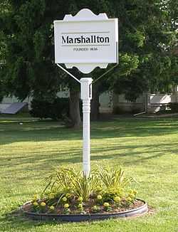
Marshallton, Delaware
| Marshallton | |
|---|---|
| Unincorporated community | |
 | |
 Marshallton | |
| Coordinates: 39°43′32″N 75°39′15″W / 39.72556°N 75.65417°WCoordinates: 39°43′32″N 75°39′15″W / 39.72556°N 75.65417°W | |
| Country | United States |
| State | Delaware |
| County | New Castle |
| Elevation | 89 ft (27 m) |
| Time zone | Eastern (EST) (UTC-5) |
| • Summer (DST) | EDT (UTC-4) |
| GNIS feature ID | 214274[1] |
Marshallton is an unincorporated community in Mill Creek Hundred, New Castle County, Delaware, United States.[1] The community was founded in 1836 and is named for John Marshall, mill owner.
History
The Greenbank Historic Area, Hickman Blacksmith Shop and House, William Julius "Judy" Johnson House, Marshallton United Methodist Church, and Springer-Cranston House are listed on the National Register of Historic Places.[2]
Geography
Marshallton is a residential suburb 5 mi/8 km W of Wilmington, on Delaware State Highway 2. Marshallton is located along Red Clay Creek; 39°44'N 75°38'W. Delaware Park Horse Racing Track to SW.
History
On August 30, 1777 George Washington ordered his army to fall back toward Red Clay Creek during the wee hours of the morning. Here, Washington arranged his troops for battle. The troops immediately dug in, building redoubts and entrenchments. Cannons were placed on a rise "for half a mile as thick as they could stand." The new encampment covered a triangular area with the towns of Newport, Marshallton, and Stanton forming the connecting points.[3]
See also
- List of Registered Historic Places in New Castle County, Delaware
- Wilmington and Western Railroad
References
- ↑ 1.0 1.1 "Marshallton". Geographic Names Information System, U.S. Geological Survey.
- ↑ "National Register Information System". National Register of Historic Places. National Park Service. 2010-07-09.
- ↑ "The Battle of Brandywine". WTJ.com. Retrieved 2008-07-27.
External links
- Historic Village of Marshallton
- Historic Village of Marshallton Civic Association
- Mill Creek Fire Company
| |||||||||||||||||||||||||||||
