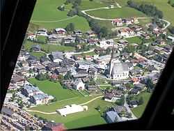
Maria Alm
| Maria Alm am Steinernen Meer | |
|---|---|
 | |
 Maria Alm am Steinernen Meer | |
| Coordinates: 47°23′00″N 12°54′00″E / 47.38333°N 12.90000°ECoordinates: 47°23′00″N 12°54′00″E / 47.38333°N 12.90000°E | |
| Country | Austria |
| State | Salzburg |
| District | Zell am See |
| Government | |
| • Mayor | Hans Langreiter (ÖVP) |
| Area | |
| • Total | 125.41 km2 (48.42 sq mi) |
| Elevation | 802 m (2,631 ft) |
| Population (1 January 2013)[1] | |
| • Total | 2,037 |
| • Density | 16/km2 (42/sq mi) |
| Time zone | CET (UTC+1) |
| • Summer (DST) | CEST (UTC+2) |
| Postal code | 5761 |
| Area code | 06584 |
| Vehicle registration | ZE |
| Website | www.maria-alm.at |
Maria Alm am Steinernen Meer is a municipality in the district of Zell am See (Pinzgau region), in the state of Salzburg in Austria, located about 5 kilometres (3.1 mi) east of Saalfelden. The population (as of December 2005) is 2,076.
Overview
Maria Alm, especially known for winter tourism, is a member of Ski Amade, a network of 28 ski areas and towns that together make up the largest ski area in Europe.
Besides skiing, Maria Alm provides facilities for cross-country skiing, golf, mountainbiking, climbing, hiking and a toboggan run. Situated at the bottom of the alps, about 400 meters from the center of town, is the Sommerstein Pool with a 40 meter water slide, a current canal, and various swimming and play areas for kids. The grounds around the pool are grassy and open making it a great space for sunbathing. The pool also offers an indoor/outdoor snack bar and lockers with changing rooms.
The villages Aberg, Alm, Bachwinkl, Enterwinkl, Griesbachwinkl, Hintermoos, Hinterthal, Krallerwinkl, Schattberg, Schloßberg and Sonnberg belong to the municipality Maria Alm as well.
Maria Alm is also part of the High King Mountain Ski Area
References
Photogallery
-

The village of Maria Alm
-

Maria Alm Church
-

Maria Alm Church with the Steinernen Meer