Margibi County
| Margibi County | ||
|---|---|---|
| County | ||
| ||
 | ||
| Coordinates: 6°30′N 10°15′W / 6.500°N 10.250°WCoordinates: 6°30′N 10°15′W / 6.500°N 10.250°W | ||
| Country |
| |
| Capital | Kakata | |
| Districts | 4 | |
| Established | 13 December 1985 | |
| Government | ||
| • Superintendent | Levi Piah | |
| Area | ||
| • Total | 2,616 km2 (1,010 sq mi) | |
| Population (2008) | ||
| • Total | 199,689 | |
| • Density | 76.3/km2 (198/sq mi) | |
| Time zone | GMT (UTC+0) | |

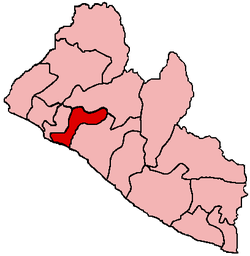
Margibi is a county on the north to central coast of the West African nation of Liberia. One of 15 counties that comprise the first-level of administrative division in the nation, it has four districts. Kakata serves as the capital with the area of the county measuring 2,616 square kilometres (1,010 sq mi).[1] As of the 2008 Census, it had a population of 199,689, making it the sixth most populous county in Liberia.[1]
Margibi's County Superintendent is Levi Piah.[2] The county is bordered by Montserrado County to the west, Grand Bassa County to the east, and Bong County on the north. The southern part of Margibi lies on the Atlantic Ocean.
History
As of the 1984 Census, the county had a population of 151,792.[1]
Districts
Districts of Margibi County include (2008 population):[1]
- Firestone District (57,251)
- Gibi District (13,232)
- Kakata District (88,130)
- Mambah-Kaba District (41,076)
References
- ↑ 1.0 1.1 1.2 1.3 "2008 National Population and Housing Census: Preliminary Results". Government of the Republic of Liberia. 2008. Retrieved 2008-10-14.
- ↑ "Liberia: Rice Production Will Ease Food Crisis - Agriculture Minister Toe". The NEWS (allAfrica.com). 9 June 2008. Retrieved 2008-10-14.
External links
- National Transitional Government of Liberia: Margibi County
- County Development Agenda
- Place name codes